Description:
Southampton: Ordnance Survey, 1929 Linen backed classic OS map with no damage to tanned folds, except for small wear to a few of the corners. There appear to be some red dots added at some point that don't seem to have any obvious reason... large trees? In VG red tanned boards with the classic 'chap in a flat cap & pipe with map outspread overlooking a wooded vale' engraving to front. Ask for a scan to assess
Search Results: ordnance survey contoured road map of
You searched for:
- Omit specific booksellers from results: World of Rare Books
- Title: ordnance survey contoured road map of
Results 1 - 20 of 105

ORDNANCE SURVEY CONTOURED ROAD MAP OF WINDSOR: Popular edition One Inch to One Mile.
- Used
- Condition
- Used
- Quantity Available
- 1
- Seller
-
Taunton, Somerset, United Kingdom
- Item Price
-
CA$7.88CA$15.68 shipping to USA
Show Details
Item Price
CA$7.88
CA$15.68
shipping to USA
Ordnance Survey Contoured Road Map Of The Isle Of Man Popular Edition
by Staff
- Used
- Very Good
- Paperback
- Condition
- Used - Very Good
- Binding
- Paperback
- Quantity Available
- 1
- Seller
-
Cooperstown, New York, United States
- Item Price
-
CA$13.80CA$10.35 shipping to USA
Show Details
Description:
Southampton, UK: Ordnance Survey Office. Very Good. 1931. Softcover. Covers have rounded corners, slight edge wear. ; Color folded map, 24 X 27, linen backed, scale one inch to one mile. Paper outer covers when folded. .
Item Price
CA$13.80
CA$10.35
shipping to USA
Ordnance Survey Contoured Road Map of Buxton & Matlock: Sheet No. 45
- Used
- Good
- Paperback
- first
- Condition
- Used - Good
- Binding
- Paperback
- Quantity Available
- 1
- Seller
-
POOLE, Dorset, United Kingdom
- Item Price
-
CA$10.51CA$15.68 shipping to USA
Show Details
Description:
Ordnance Survey, 1923. Book. Good. Soft cover. 12mo - over 6¾ - 7¾" tall. 1923 cloth bound. Map face is exceptionally clean, cloth backing has some foxing and small marks. Covers dingy and slightly concertinaed. 1st class posting from UK within 1 business day of order receipt..
Item Price
CA$10.51
CA$15.68
shipping to USA
Ordnance Survey: Contoured Road Map of Prestatyn to Bangor
by Anon
- Used
- Paperback
- Condition
- Used
- Binding
- Paperback
- Quantity Available
- 1
- Seller
-
Lincoln, Lincolnshire, United Kingdom
- Item Price
-
CA$4.38CA$22.33 shipping to USA
Show Details
Description:
Colonel E.M. Jack, 1930. This is an ex-library book and may have the usual library/used-book markings inside.This book has soft covers. In fair condition, suitable as a study copy. Please note the Image in this listing is a stock photo and may not match the covers of the actual item,150grams, ISBN:
Item Price
CA$4.38
CA$22.33
shipping to USA

More Photos
ORDNANCE SURVEY CONTOURED ROAD MAP OF BOSCASTLE AND PADSTOW
by ---------------
- Used
- fair
- Paperback
- Condition
- Used - Fair
- Binding
- Paperback
- Quantity Available
- 1
- Seller
-
Brighton, East Sussex, United Kingdom
- Item Price
-
CA$7.01CA$20.67 shipping to USA
Show Details
Description:
SOUTHAMPTON: ORDNANCE SURVEY HMSO Red and Black card covers, mounted on linen,190x110mm approx folded.Sheet 136. Cover art by Ellis Martin. Popular Edition, 1" to 1 mile. Cover price 2/6 Net Minor corrections to 1927 Reprint 3800/31 Fair (Covers rubbed and shelf soiled with chips, Previous owner name in ink crossed through in ink to rear cover. Map a little shelf soiled at exposed folds but no significant wear and otherwise clean). Please see our image of the actual map offered for sale.
Item Price
CA$7.01
CA$20.67
shipping to USA
ORDNANCE SURVEY CONTOURED ROAD MAP OF CHICHESTER AND WORTHING. Popular edition One Inch to One Mile. Sheet 133
- Used
- Condition
- Used
- Quantity Available
- 1
- Seller
-
Taunton, Somerset, United Kingdom
- Item Price
-
CA$13.14CA$15.68 shipping to USA
Show Details
Description:
Southampton: Ordnance Survey, 1935 Linen backed classic OS map with no damage to folds internally, except v. slight wear to a few corners, in VG red tanned boards with the classic 'chap in a flat cap & pipe with map outspread overlooking a wooded vale' engraving to front. Ask for a scan to assess
Item Price
CA$13.14
CA$15.68
shipping to USA
ORDNANCE SURVEY CONTOURED ROAD MAP OF WINDERMERE AND ULVERSTON. Popular edition One Inch to One Mile. Sheet 19
- Used
- Condition
- Used
- Quantity Available
- 1
- Seller
-
Taunton, Somerset, United Kingdom
- Item Price
-
CA$14.89CA$15.68 shipping to USA
Show Details
Description:
Southampton: Ordnance Survey, 1934 Linen backed classic OS map with no damage to folds, except for small wear to a few of the corners. In VG red tanned boards with the classic 'chap in a flat cap & pipe with map outspread overlooking a wooded vale' engraving to front. Ask for a scan to assess
Item Price
CA$14.89
CA$15.68
shipping to USA
ORDNANCE SURVEY CONTOURED ROAD MAP OF BUXTON & MATLOCK. Popular edition one inch map Sheet 45.
- Used
- Condition
- Used
- Quantity Available
- 1
- Seller
-
Taunton, Somerset, United Kingdom
- Item Price
-
CA$14.89CA$15.68 shipping to USA
Show Details
Description:
Southampton: Ordnance Survey, 1936 Linen backed classic OS map with no damage to folds internally in VG red tanned boards with the classic 'chap in a flat cap & pipe with map outspread overlooking a wooded vale' engraving to front. Ask for a scan to assess
Item Price
CA$14.89
CA$15.68
shipping to USA

More Photos
ORDNANCE SURVEY Contoured Road Map of WINDSOR. Popular Edition - Scale one inch to one mile. Sheet 114.
by ---------
- Used
- Good
- Paperback
- Condition
- Used - Good
- Binding
- Paperback
- Quantity Available
- 1
- Seller
-
Brighton, East Sussex, United Kingdom
- Item Price
-
CA$10.51CA$20.67 shipping to USA
Show Details
Description:
SOUTHAMPTON: DIRECTOR GENERAL , 1933 Red and cream card covers with Black line image. 180 x 95 mm approx folded. 1933 Popular Edition Sheet 114 mounted on linen.(10,000/33). Please see our images of the actual map offered for sale for further details and condition. Good (Cover- F J Cates Crown Library bookseller label to bottom front panel and faded ink previous owner name to top margin. Heavy rubbing to front cover. Map respectably clean with longitudinal crease where folded other than usual panel width. No other notable defects).
Item Price
CA$10.51
CA$20.67
shipping to USA
Ordnance Survey Contoured Road Map of Land's End and Lizard. Popular Edition. Sheet 146;
by Ordnance Survey
- Used
- Paperback
- Condition
- Used
- Binding
- Paperback
- Quantity Available
- 1
- Seller
-
Selkirk, United Kingdom
- Item Price
-
CA$17.52CA$17.43 shipping to USA
Show Details
Description:
Southampton Ordnance Survey, nd ( c 1926);. Softcover. Good+ condition. Linen-backed folded map in pictorial card covers. Scale 1 mile to the inch. Full colour road map with contours. Map is clean, lightly rubbed at folds. .
Item Price
CA$17.52
CA$17.43
shipping to USA

Ordnance Survey contoured road map of Birmingham: sheet 72
by Anon
- Used
- Good
- Paperback
- Condition
- Used - Good
- Edition
- Reprint
- Binding
- Paperback
- Quantity Available
- 1
- Seller
-
Ibstock, Leicestershire, United Kingdom
- Item Price
-
CA$8.76CA$26.27 shipping to USA
Show Details
Description:
Ordnance Survey. Good. 1931. Reprint. Softcover. Foldout map, 1 mile to 1 inch, with pictorial red card covers (11 x 19.5 cm) which are rubbed and creased with minor loss at the bottom right corner and a small closed tear to right edge. Opens out to 56 x 75 cm, linen backed map with minor wear at folds, no inscriptions; .
Item Price
CA$8.76
CA$26.27
shipping to USA

More Photos
ORDNANCE SURVEY Contoured Road Map of CROMER. Popular Edition - Scale one inch to one mile. Sheet 58.
by ---------
- Used
- Good
- Paperback
- Condition
- Used - Good
- Binding
- Paperback
- Quantity Available
- 1
- Seller
-
Brighton, East Sussex, United Kingdom
- Item Price
-
CA$14.01CA$20.67 shipping to USA
Show Details
Description:
SOUTHAMPTON: DIRECTOR GENERAL , 1922 Red and cream card covers with Black line image. 180 x 95 mm approx folded. 1922 Popular Edition Sheet 58 printed on paper. Please see our images of the actual map offered for sale for further details and condition. Good (Cover- remnants of original retailer sticker to front bottom corner. Mild general shelf wear and soiling. 6 and 4 cm approx conservation tape repairs to tears to front and rear folds. No other notable defects).
Item Price
CA$14.01
CA$20.67
shipping to USA

More Photos
Ordnance Survey Contoured Road Map of Fakenham - Popular Edition - Sheet 87 - 1 inch to 1 mile
by -----------
- Used
- Very Good
- Paperback
- Signed
- Condition
- Used - Very Good
- Binding
- Paperback
- Quantity Available
- 1
- Seller
-
Brighton, East Sussex, United Kingdom
- Item Price
-
CA$14.01CA$20.67 shipping to USA
Show Details
Description:
Southampton: CHARLES CLOSE DIRECTOR GENERAL ORDNANCE SURVEY, 1921 Red Black Illust. Card covers.3/6. 185x105mm approx. folded.Mounted on linen. 1921 printing of sheet no 87. VG (Covers- respectably clean with no notable soiling. No previous owner name or insc. No annotations to map. A few foxing spots to exposed edges of linen folds. No other notable defects.Please see our image of the actual map offered for sale.
Item Price
CA$14.01
CA$20.67
shipping to USA
ORDNANCE SURVEY MAP: ONE-INCH MAP: CONTOURED ROAD MAP OF CROMER Popular Edition.
- Used
- Condition
- Used - VG+
- Quantity Available
- 1
- Seller
-
WINTERTON, Lincolnshire, United Kingdom
- Item Price
-
CA$12.24CA$22.77 shipping to USA
Show Details
Description:
GB: Ordnance Survey "Reprint 3500/29." Presumably 1929. Linen backed.. VG+.
Item Price
CA$12.24
CA$22.77
shipping to USA
MAP: ORDNANCE SURVEY: ONE INCH TO ONE MILE: SHEET 135: CONTOURED ROAD MAP OF HASTINGS
- Used
- Paperback
- Condition
- Used - VG-
- Binding
- Paperback
- Quantity Available
- 1
- Seller
-
WINTERTON, Lincolnshire, United Kingdom
- Item Price
-
CA$12.73CA$22.77 shipping to USA
Show Details
Description:
GB: Ordnance Survey, 1921. Cloth map (roughly) 770 x 540 mm. in card covers which folds to 180 x 95 mm. About 1921. Map is in very good minus condition with minor but noticeable signs of wear and/or age.. Paperback. VG-.
Item Price
CA$12.73
CA$22.77
shipping to USA
MAP: ORDNANCE SURVEY: ONE INCH TO ONE MILE: SHEET 49: CONTOURED ROAD MAP OF PORTMADOC AND CRICCIETH
- Used
- Paperback
- Condition
- Used - VG-
- Binding
- Paperback
- Quantity Available
- 1
- Seller
-
WINTERTON, Lincolnshire, United Kingdom
- Item Price
-
CA$12.73CA$22.77 shipping to USA
Show Details
Description:
GB: Ordnance Survey, 1933. Cloth map (roughly) 970 x 680 mm. in card covers which folds to 190 x 110 mm. About 1933. Map is in very good minus condition with minor but noticeable signs of wear and/or age.. Paperback. VG-.
Item Price
CA$12.73
CA$22.77
shipping to USA
MAP: ORDNANCE SURVEY: ONE INCH TO ONE MILE: SHEET 12: CONTOURED ROAD MAP OF KESWICK AND AMBLESIDE
- Used
- Paperback
- Condition
- Used - nrVG
- Binding
- Paperback
- Quantity Available
- 1
- Seller
-
WINTERTON, Lincolnshire, United Kingdom
- Item Price
-
CA$12.73CA$22.77 shipping to USA
Show Details
Description:
GB: Ordnance Survey, 1933. Name of owner on inside of front cover. Cloth map (roughly) 750 x 560 mm. in card covers which folds to 190 x 110 mm. About 1933. Map is in near very good condition with minor but just noticeable signs of wear and/or age.. Paperback. nrVG.
Item Price
CA$12.73
CA$22.77
shipping to USA
MAP: ORDNANCE SURVEY: ONE INCH TO ONE MILE: SHEET 117: CONTOURED ROAD MAP OF EAST KENT
- Used
- Good
- Paperback
- Condition
- Used - Good
- Binding
- Paperback
- Quantity Available
- 1
- Seller
-
WINTERTON, Lincolnshire, United Kingdom
- Item Price
-
CA$12.73CA$22.77 shipping to USA
Show Details
Description:
GB: Ordnance Survey, 1923. Cloth map (roughly) 770 x 540 mm. in card covers which folds to 180 x 95 mm. About 1923. Map is in only good (that is, fair or average) condition with major signs of wear and/or age.. Paperback. Good.
Item Price
CA$12.73
CA$22.77
shipping to USA
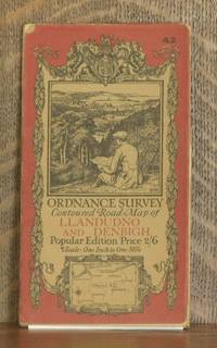
ORDNANCE SURVEY CONTOURED ROAD MAP OF LLANDUDNO AND DENBIGH Popular edition Scale 1 inch to 1 mile- Sheet # 42
by Ordnance Survey
- Used
- Very Good
- Condition
- Used - Very Good
- Edition
- Third revised edition
- Quantity Available
- 1
- Seller
-
Blue Hill, Maine, United States
- Item Price
-
CA$27.59CA$8.28 shipping to USA
Show Details
Description:
Southampton: Ordnance Survey Office/ Charles Close Dir., 1928. Third revised edition. Map. Very Good. 4 X 7 in. high. unfolds to 30 X 25 inches. Condition of the book is VERY GOOD; Map is very clean, lightly rubbed at folds, but no splits or tears. Geography Ephemera
Item Price
CA$27.59
CA$8.28
shipping to USA

ORDNANCE SURVEY CONTOURED ROAD MAP OF PEMBROKE AND TENBY Popular edition Scale 1 inch to 1 mile- Sheet # 99
by Ordnance Survey
- Used
- Very Good
- Condition
- Used - Very Good
- Edition
- Third revised edition
- Quantity Available
- 1
- Seller
-
Blue Hill, Maine, United States
- Item Price
-
CA$27.59CA$8.28 shipping to USA
Show Details
Description:
Southampton: Ordnance Survey Office/ Charles Close Dir., 1930. Third revised edition. Map. Very Good. 4 X 7 in. high. unfolds to 38 X 24 1/2 inches. Condition of the book is VERY GOOD; Map is very clean, lightly rubbed at folds, but no splits or tears. Geography Ephemera
Item Price
CA$27.59
CA$8.28
shipping to USA

Didn’t find what you’re looking for?
Try adding this search to your want list. Millions of books are added to our site everyday and when we find one that matches your search, we’ll send you an email. Best of all, it’s free.
Add to Want List

Are you a frequent reader or book collector?
Join the Bibliophile's Club and save 10% on every purchase, every day — up to $20 savings per order!

Social Responsibility
Did you know that since 2004, Biblio has used its profits to build 16 public libraries in rural villages of South America?
