Description:
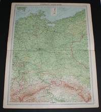
The Times, London, 1920. First Edition. Softcover. Very Good Condition/No Dust Jacket. Disbound single sheet with horizontal centre fold from the 1920 "The Times Survey Atlas of the World". Map is in colour and suitable for framing. Colour is according to contour, boundaries of countries and regions/states are in red. Map at scale 1:1,000,000. Map coversSchleswig-Holstein, Oldenburg, Hanover, Westphalia, Hessen, Prussia, Heliogoland Bay, East Frisian Islands, Mecklenburg Bay, etc. and part of Holland and the Denmark border. Cities include Hamburg, Lubeck, Bremen, Essen, Hanover, Brunswick, Magdeburg, Cologne, Dusseldorf, Erfurt, Cassel, Weimar, Coblenz and Kiel, Groningen, etc. Sheet includes small inset plan of Berlin. Slightly darkened and worn edges with foxing in margins, sheet is otherwise clean, bright and crisp. Size: 58cm x 46cm approx. Quantity Available: 1. Shipped Weight: under 1 kg. Pictures of this item not already displayed here available upon request. Inventory No:…
Read More Search Results: Russia & Eastern Europe from Bailgate Books Ltd
You searched for:
- Bookseller: Bailgate Books Ltd
- Subject: Russia & Eastern Europe from Bailgate Books Ltd
Results 21 - 40 of 63
More Photos
Map of "Germany - Eastern Section" from 1920 Times Atlas (Plate 41) including Berlin, Magdeburg, Leipzip, Dresden, Chemnitz, Halle, Breslau, Posen, Stettin, Stralsund, Gorlitz, Liegnitz, Dessau, etc
by The Times and J. G. Bartholomew
- Used
- Paperback
- first
- Condition
- Used - Very Good Condition
- Edition
- First Edition
- Binding
- Paperback
- Quantity Available
- 1
- Seller
-
Doncaster, Aberdeen, United Kingdom
- Item Price
-
CA$38.85CA$25.61 shipping to USA
Show Details
Item Price
CA$38.85
CA$25.61
shipping to USA

More Photos
Map of 'North China and Mongolia' - Plate 21 disbound from 1958 Mid-Century Times Atlas of the World, including Ulan-Ude, Chita, Ulan Bator, Peking, Tientsin, Tsingtao and Lanchow
by John Bartholomew
- Used
- Paperback
- Condition
- Used - Very Good Condition
- Edition
- Mid-Century Edition
- Binding
- Paperback
- Quantity Available
- 1
- Seller
-
Doncaster, Aberdeen, United Kingdom
- Item Price
-
CA$45.92CA$25.61 shipping to USA
Show Details
Description:
The Times Publishing Company Ltd, London, 1958. Mid-Century Edition. Softcover. Very Good Condition/No Dust Jacket. Single disbound map sheet from 'The Times Atlas of the World, Mid-Century Edition; Volume I The World, Australia & East Asia' suitable for framing. Map is in colour and has vertical centre fold. Approx sheet size is 49 x 61cm. Sheet is clean, bright and crisp. Map covers part of north China, Mongolia and the Russian border north of Mongolia. Included are Ulan-Ude, Chita, Ulan Bator, Peking (Beijing), Tientsin, Tsingtao, Lanchow, Barkol and part of the Sinkiang Uighur Region and the Inner Mongolian Region. Small inset plan of Peking in bottow left corner. Road and railway routes are shown. First printing of this edition. Quantity Available: 1. Shipped Weight: under 1 kg. Pictures of this item not already displayed here available upon request. Inventory No: 45021024045. For international tracking please select Priority shipping service..
Item Price
CA$45.92
CA$25.61
shipping to USA
More Photos
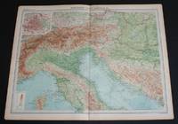
Map of "Northern Italy, Austria, etc." from 1920 Times Atlas (Plate 36) including Turin, Milan, Verona, Trieste, Venice, Florence, Ravenna, Bologna, Rome, Munich, Vienna, Budapest, Salzberg, Elba, etc
by The Times and J. G. Bartholomew
- Used
- Paperback
- first
- Condition
- Used - Very Good Condition
- Edition
- First Edition
- Binding
- Paperback
- Quantity Available
- 1
- Seller
-
Doncaster, Aberdeen, United Kingdom
- Item Price
-
CA$38.85CA$25.61 shipping to USA
Show Details
Description:
The Times, London, 1920. First Edition. Softcover. Very Good Condition/No Dust Jacket. Disbound single sheet with vertical centre fold from the 1920 "The Times Survey Atlas of the World". Map is in colour and suitable for framing. Colour is according to contour, boundaries of countries or regions are in red. Map at scale 1:2,000,000 with small inset plan of Vienna at 1:150,000. Map covers northern Italy, the northern half of Corsica, Austria, Liechtenstein,and parts of modern day Croatia, Slovenia, Bosnia and Herzegovina, Hungary, Montenegro, Germany, Switzerland and Slovakia. Map includes Turin, Milan, Verona, Trieste, Venice, Florence, Ravenna, Bologna, Rome, Munich, Vienna, Budapest, Salzberg, Elba, and parts of the Ligurian and Adriatic Seas, etc. Slightly darkened edges with occasional light foxing in margins and along centre fold. Edges at bottom corners are very slightly roughened. Sheet is otherwise clean, crisp and bright. Size: 46cm x 58cm approx. Quantity Available: 1.…
Read More Item Price
CA$38.85
CA$25.61
shipping to USA

More Photos
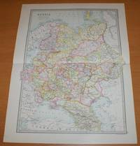
Map of 'Northern Asia and Central Asia' - Sheet 44 disbound from the 1890 'The Library Reference Atlas of the World' including modern day Siberia, Kazakhstan, Turkmenistan, Uzbekistan and Mongolia
by John Bartholomew
- Used
- Paperback
- first
- Condition
- Used - Very Good Condition
- Edition
- First Edition
- Binding
- Paperback
- Quantity Available
- 1
- Seller
-
Doncaster, Aberdeen, United Kingdom
- Item Price
-
CA$63.58CA$25.61 shipping to USA
Show Details
Description:
Macmillan and Co, London, 1890. First Edition. Softcover. Very Good Condition/No Dust Jacket. Single disbound coloured map sheet, from John Bartholomew's Library Reference Atlas. Sheet is divided into to map panels showing 'Northern Asia' and 'Central Asia' (Central is at closer scale). Suitable for framing. Approx size 46 x 35cm, horizontal centre fold. Occasional light foxing in margins, map is otherwise clean, crisp and bright. Area covered includes Kara Sea, New Siberia Islands, Maritime Province, Sea of Okhotsk, Sea of Japan, Russian Empire, Siberia, Ural Mountains, Yakutsk, Tomsk, Manchuria, Turkestan, Mongolia, Khiva, Caspain Sea, Aral Sea, Bokhara, and parts of Lapland, Persia, Kashmir, Afghanistan, Japan and China. This includes modern day Kazakhstan, Turkmenistan, Uzbekistan, Kyrgyzstan and Tajikistan. No dust jacket, as published. Quantity Available: 1. Shipped Weight: under 1 kg. Pictures of this item not already displayed here available upon request. Inventory No:…
Read More Item Price
CA$63.58
CA$25.61
shipping to USA
More Photos
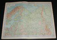
Map of "Northern Russia & Finland" from 1920 Times Atlas (Plate 45) including Moscow, Petrograd (St Petersburg) and covering Finland, Lapland, Estonia, Latvia, Lithuania and north Russia as far east as Ural Mountains and Gulf of Ob
by The Times and J. G. Bartholomew
- Used
- Paperback
- first
- Condition
- Used - Very Good Condition
- Edition
- First Edition
- Binding
- Paperback
- Quantity Available
- 1
- Seller
-
Doncaster, Aberdeen, United Kingdom
- Item Price
-
CA$38.85CA$25.61 shipping to USA
Show Details
Description:
The Times, London, 1920. First Edition. Softcover. Very Good Condition/No Dust Jacket. Map Disbound single sheet with vertical centre fold from the 1920 "The Times Survey Atlas of the World". Map is in colour and suitable for framing. Colour is according to contour, boundaries of countries or regions are in red. Map at scale 1:6,000,000. Map includes Moskva/Moscow, Petrograd (St Petersburg), Riga, Warsaw, Stockholm, Helsinki, and covers Finland, Lapland, Estonia, Latvia, Lithuania and northern Russia as far east as the Ural Mountains and Gulf of Ob, Tobolsk, Vologda, Archanangel, Orenburg, White Sea, Kara Sea (part), Baltic Sea (part), Gulf of Bothnia, etc. Slightly darkened edges with occasional light foxing in margins, sheet is otherwise clean and crisp. Item Type: Map. Single sheet map/chart which is suitable for framing and will be shipped rolled and in a cardboard tube. Quantity Available: 1. Shipped Weight: under 1 kg. Pictures of this item not already displayed here available upon…
Read More Item Price
CA$38.85
CA$25.61
shipping to USA

More Photos
Map of North East China, Korea, Sea of Japan and Japan - Plate 20 disbound from 1958 Mid-Century Times Atlas of the World, including Vladivostock, Khabarovsk, Harbin, Pyongyang, Seoul, Pusan, Osaka and Tokyo
by John Bartholomew
- Used
- Paperback
- Condition
- Used - Very Good Condition
- Edition
- Mid-Century Edition
- Binding
- Paperback
- Quantity Available
- 1
- Seller
-
Doncaster, Aberdeen, United Kingdom
- Item Price
-
CA$45.92CA$25.61 shipping to USA
Show Details
Description:
The Times Publishing Company Ltd, London, 1958. Mid-Century Edition. Softcover. Very Good Condition/No Dust Jacket. Single disbound map sheet from 'The Times Atlas of the World, Mid-Century Edition; Volume I The World, Australia & East Asia' suitable for framing. Map is in colour and has horizontal centre fold. Approx sheet size is 61 x 49cm. Sheet is clean, bright and crisp. Map covers north east China, Korea, Sea of Japan, Japan and parts of eastern Russia (USSR). Included are Vladivostock, Khabarovsk, Harbin, Pyongyang, Seoul, Pusan, Osaka, Tokyo, Sakhalin, Shenyang, etc. Road and railway routes are shown. First printing of this edition. Quantity Available: 1. Shipped Weight: under 1 kg. Pictures of this item not already displayed here available upon request. Inventory No: 45021024044. For international tracking please select Priority shipping service..
Item Price
CA$45.92
CA$25.61
shipping to USA
More Photos
Map of 'Russia in Europe' - Sheet 40 disbound from the 1890 'The Library Reference Atlas of the World' including Finland, Lapland and Poland and modern day Ukraine, Belarus, Latvia, Lithuania, Estonia,Georgia and Azebaijan
by John Bartholomew
- Used
- Paperback
- first
- Condition
- Used - Very Good Condition
- Edition
- First Edition
- Binding
- Paperback
- Quantity Available
- 1
- Seller
-
Doncaster, Aberdeen, United Kingdom
- Item Price
-
CA$63.58CA$25.61 shipping to USA
Show Details
Description:
Macmillan and Co, London, 1890. First Edition. Softcover. Very Good Condition/No Dust Jacket. Single disbound coloured map sheet, from John Bartholomew's Library Reference Atlas. Suitable for framing. Approx size 46 x 35cm, horizontal centre fold. Faint smudges in margin, map is clean, crisp and bright. Sheet covers what was known as 'Russia in Europe' and extends as far east as the Ural Mountains. The mapped area covers what is now Ukraine, Belarus, Latvia, Lithuania, Estonia,Georgia, Azebaijan and part of Russia. Also included are Finland and parts of Norway and Sweden, part of modern Poland, the Black Sea, Constantinople (Istambul), Sea of Azof, Caspian Sea (part), Kara Sea (part), Gulf of Bothnia, Whie Sea, etc. No dust jacket, as published. Quantity Available: 1. Shipped Weight: under 1 kg. Pictures of this item not already displayed here available upon request. Inventory No: 45021014020. For international tracking please select Priority shipping service..
Item Price
CA$63.58
CA$25.61
shipping to USA
More Photos
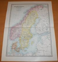
Map of Sweden, Norway, Denmark and the Baltic - Sheet 39 disbound from the 1890 'The Library Reference Atlas of the World'
by John Bartholomew
- Used
- Paperback
- first
- Condition
- Used - Very Good Condition
- Edition
- First Edition
- Binding
- Paperback
- Quantity Available
- 1
- Seller
-
Doncaster, Aberdeen, United Kingdom
- Item Price
-
CA$63.58CA$25.61 shipping to USA
Show Details
Description:
Macmillan and Co, London, 1890. First Edition. Softcover. Very Good Condition/No Dust Jacket. Single disbound coloured map sheet, from John Bartholomew's Library Reference Atlas. Suitable for framing. Approx size 46 x 35cm, horizontal centre fold. Map is clean, crisp and bright, slight split at right edge of fold. Sweden, Norway and Denmark are coloured in pastel shades, surrounding parts of Russia, Finland and Germany are mapped but not coloured. Map includes Baltoc Sea, Gulf of Bothnia, Gulf of Finland, St. Petersburg, Riga, Danzig, Schleswig-Holstein, Hamburg, Gothland, Skager Rack, Lofoden Islands, Varanger Fjord, etc. No dust jacket, as published. Quantity Available: 1. Shipped Weight: under 1 kg. Pictures of this item not already displayed here available upon request. Inventory No: 45021014019. For international tracking please select Priority shipping service..
Item Price
CA$63.58
CA$25.61
shipping to USA
More Photos
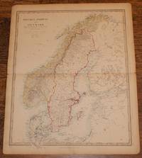
Map of Sweden, Norway and Denmark - disbound sheet from 1857 "University Atlas
by Edward Stanford, J. & C. Walker
- Used
- Paperback
- first
- Condition
- Used - Good Condition
- Edition
- First Edition
- Binding
- Paperback
- Quantity Available
- 1
- Seller
-
Doncaster, Aberdeen, United Kingdom
- Item Price
-
CA$49.45CA$25.61 shipping to USA
Show Details
Description:
Edward Stanford, London, 1857. First Edition. Softcover. Good Condition/No Dust Jacket. Disbound single Sheet Map with horizontal centre fold from "The University Atlas of Classical and Modern Geography, including all the Recent Geographical Discoveries". Sheet is a little foxed with darkened edges. Some wear and minor damage to edges and corners. Fold is slightly split at both ends and a little fragile. Full title is "Sweden, Norway and Denmark including the Baltic Sea & Russian Provinces Adjacent" which includes parts of what is now Finland, Estonia and Latvia (labeled as Russia). Bright coloured lines mark the boundaries of Sweden, Norway and Denmark, pale blue marks coast lines. Quantity Available: 1. Shipped Weight: under 1 kg. Pictures of this item not already displayed here available upon request. Inventory No: 45019044031. For international tracking please select Priority shipping service..
Item Price
CA$49.45
CA$25.61
shipping to USA
More Photos
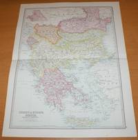
Map of 'Turkey in Europe, Greece, Roumania, Servia &c.' - Sheet 35 disbound from the 1890 'The Library Reference Atlas of the World' covering modern day Greece, Albania, Bulgaria and North Macedonia
by John Bartholomew
- Used
- Paperback
- first
- Condition
- Used - Very Good Condition
- Edition
- First Edition
- Binding
- Paperback
- Quantity Available
- 1
- Seller
-
Doncaster, Aberdeen, United Kingdom
- Item Price
-
CA$63.58CA$25.61 shipping to USA
Show Details
Description:
Macmillan and Co, London, 1890. First Edition. Softcover. Very Good Condition/No Dust Jacket. Single disbound coloured map sheet, from John Bartholomew's Library Reference Atlas. Map covers modern day Greece, Albania, Bulgaria, North Macedonia, Montenegro, Kosovo and parts of Romania, Serbia and Moldova. Suitable for framing. Approx size 46 x 35cm, horizontal centre fold. Map is clean, crisp, clear and bright. Occasional light foxing in margin. Countries/States are shaded in pastel colours and include Roumania, Bulgaria, Servia, Eastern Roumelia, Montenegro, Moldavia, Turkey (in Europe), Greece and Crete or Candia. Parts of Hungary, Bosnia, Asia Minor and Russia around the edges of the sheet are not shaded. No dust jacket, as published. Quantity Available: 1. Shipped Weight: under 1 kg. Pictures of this item not already displayed here available upon request. Inventory No: 45021014015. For international tracking please select Priority shipping service..
Item Price
CA$63.58
CA$25.61
shipping to USA

More Photos
Map of U.S.S.R. Central Asia, Kazakhstan, Plate 43 disbound from 1959 Mid-Century Times Atlas of the World, Volume II, (South-West Asia & Russia) Scale 1: 5,000,000. Tadzhikiztan,Kirgizeya. Inset Fergana Basin 1: 2,5000,000
by John Bartholomew
- Used
- Paperback
- Condition
- Used - Fine Condition
- Edition
- Mid-Century Edition
- Binding
- Paperback
- Quantity Available
- 1
- Seller
-
Doncaster, Aberdeen, United Kingdom
- Item Price
-
CA$49.45CA$25.61 shipping to USA
Show Details
Description:
The Times Publishing Company Ltd, London, 1959. Mid-Century Edition. Softcover. Fine Condition/No Dust Jacket. Single disbound map sheet from 'The Times Atlas of the World, Mid-Century Edition; Volume II Eurasia, suitable for framing. Map is in colour and has vertical centre fold. Approx. sheet size is 49 x 61cm. Sheet is clean, bright and crisp. Scale 1:5,000,000. Includes parts of Iran, Afghanistan, Pakistan, Jammu and Kashmir, China. Map shows relief,International S.S.R. boundaries A.S.S.R, Oblast and Kray boundaries, cities, town, rivers, main roads, railways, main civil airports and other airfields, canals, Ice caps and glaciers, marsh and flood areas, sand, salt lakes, salt marshes. Key map on reverse and glossary of Russian Geographical Terms and Abbreviations of Principal Soviet Administrative Areas. First printing of this edition. Single sheet map/chart which is suitable for framing and will be shipped rolled and in a cardboard tube. Quantity Available: 1. Shipped Weight: under 1 kg.…
Read More Item Price
CA$49.45
CA$25.61
shipping to USA

More Photos
Map of U.S.S.R. Kolyma, Kamchatka, Plate 39 disbound from 1959 Mid-Century Times Atlas of the World, Volume II, (South-West Asia & Russia) Scale 1: 5,000,000. Small part of Alaska, inset map of O. Vrangelya (Wrangel Island)
by John Bartholomew
- Used
- Paperback
- Condition
- Used - Fine Condition
- Edition
- Mid-Century Edition
- Binding
- Paperback
- Quantity Available
- 1
- Seller
-
Doncaster, Aberdeen, United Kingdom
- Item Price
-
CA$49.45CA$25.61 shipping to USA
Show Details
Description:
The Times Publishing Company Ltd, London, 1959. Mid-Century Edition. Softcover. Fine Condition/No Dust Jacket. Single disbound map sheet from 'The Times Atlas of the World, Mid-Century Edition; Volume II Eurasia, suitable for framing. Map is in colour and has vertical centre fold. Approx. sheet size is 49 x 61cm. Sheet is clean, bright and crisp. Scale 1:5,000,000 Also shows Saint Lawrence Island, Aleutian Islands, Saint Matthew Island, Komandorskiye Ostrova. Map shows relief, national boundaries, cities, town, rivers, main roads, , railways, main civil airports and other airfields. Key map on reverse and glossary of Russian Geographical Terms and Abbreviations of Principal Soviet Administrative Areas. First printing of this edition. Quantity Available: 1. Shipped Weight: under 1 kg. Pictures of this item not already displayed here available upon request. Inventory No: 45022081072. For international tracking please select Priority shipping service..
Item Price
CA$49.45
CA$25.61
shipping to USA

More Photos
Map of U.S.S.R. Leningrad, Urals, Plate 47 disbound from 1959 Mid-Century Times Atlas of the World, Volume II, (South-West Asia & Russia) Scale 1: 5,000,000. Inset plans of Industrial Urals 1:2,500,000 and Leningrad 1:100,000
by John Bartholomew
- Used
- Paperback
- Condition
- Used - Fine Condition
- Edition
- Mid-Century Edition
- Binding
- Paperback
- Quantity Available
- 1
- Seller
-
Doncaster, Aberdeen, United Kingdom
- Item Price
-
CA$56.51CA$25.61 shipping to USA
Show Details
Description:
The Times Publishing Company Ltd, London, 1959. Mid-Century Edition. Softcover. Fine Condition/No Dust Jacket. Single disbound map sheet from 'The Times Atlas of the World, Mid-Century Edition; Volume II Eurasia, suitable for framing. Map is in colour and has vertical centre fold. Approx. sheet size is 49 x 61cm. Sheet is clean, bright and crisp. Scale 1:2,5000,000. Includes parts of Finland, Norway, Sweden Map shows relief, International Boundaries, S.S.R. boundaries A.S.S.R, Oblast boundaries, cities, town, rivers, main roads, railways, main civil airports and other airfields, canals, oil pipe lines, marsh and flood areas, salt lakes. Leningrad inset shows stations, parks, road grid, state buildings, hotels, museums etc. Key map on reverse and glossary of Russian Geographical Terms and Abbreviations of Principal Soviet Administrative Areas. First printing of this edition. Single sheet map/chart which is suitable for framing and will be shipped rolled and in a cardboard tube. Quantity…
Read More Item Price
CA$56.51
CA$25.61
shipping to USA

More Photos
Map of U.S.S.R. Caucasus, Crimea, Plate 44 disbound from 1959 Mid-Century Times Atlas of the World, Volume II, (South-West Asia & Russia) Scale 1: 2.500,000. Inset Crimea 1: 2,5000,000
by John Bartholomew
- Used
- Paperback
- Condition
- Used - Fine Condition
- Edition
- Mid-Century Edition
- Binding
- Paperback
- Quantity Available
- 1
- Seller
-
Doncaster, Aberdeen, United Kingdom
- Item Price
-
CA$60.04CA$25.61 shipping to USA
Show Details
Description:
The Times Publishing Company Ltd, London, 1959. Mid-Century Edition. Softcover. Fine Condition/No Dust Jacket. Single disbound map sheet from 'The Times Atlas of the World, Mid-Century Edition; Volume II Eurasia, suitable for framing. Map is in colour and has vertical centre fold. Approx. sheet size is 49 x 61cm. Sheet is clean, bright and crisp. Scale 1:2,5000,000. Includes Armenia, Azerbaydzhan, Georgia,Chechnya, and parts of Kazakhstan, Iran, Turkey, Ukraina. Map shows relief,International S.S.R. boundaries A.S.S.R, Oblast boundaries, cities, town, rivers, main roads, railways, main civil airports and other airfields, oil pipe lines, canals, marsh and flood areas, salt lakes, salt marshes. Key map on reverse and glossary of Russian Geographical Terms and Abbreviations of Principal Soviet Administrative Areas. First printing of this edition. Single sheet map/chart which is suitable for framing and will be shipped rolled and in a cardboard tube. Quantity Available: 1. Shipped Weight: under 1…
Read More Item Price
CA$60.04
CA$25.61
shipping to USA

More Photos
Map of U.S.S.R. Khabarovsk, Vladivostok, Plate 40 disbound from 1959 Mid-Century Times Atlas of the World, Volume II, (South-West Asia & Russia) Scale 1: 5,000,000. Includes small part of Japan
by John Bartholomew
- Used
- Paperback
- Condition
- Used - Fine Condition
- Edition
- Mid-Century Edition
- Binding
- Paperback
- Quantity Available
- 1
- Seller
-
Doncaster, Aberdeen, United Kingdom
- Item Price
-
CA$49.45CA$25.61 shipping to USA
Show Details
Description:
The Times Publishing Company Ltd, London, 1959. Mid-Century Edition. Softcover. Fine Condition/No Dust Jacket. Single disbound map sheet from 'The Times Atlas of the World, Mid-Century Edition; Volume II Eurasia, suitable for framing. Map is in colour and has vertical centre fold. Approx. sheet size is 49 x 61cm. Sheet is clean, bright and crisp. Scale 1:5,000,000. Includes Kurilskiye Ostrova (Kuril Islands) and its volcanoes. Map shows relief, Oblast and Kray Boundaries, cities, town, rivers, main roads, railways, main civil airports and other airfields, active volcanoes. Key map on reverse and glossary of Russian Geographical Terms and Abbreviations of Principal Soviet Administrative Areas. First printing of this edition. Quantity Available: 1. Shipped Weight: under 1 kg. Pictures of this item not already displayed here available upon request. Inventory No: 45022081073. For international tracking please select Priority shipping service..
Item Price
CA$49.45
CA$25.61
shipping to USA

More Photos
Map of U.S.S.R. Kuznetz, Irkutz, Plate 42 disbound from 1959 Mid-Century Times Atlas of the World, Volume II, (South-West Asia & Russia) Scale 1: 5,000,000. Part of Mongolia, small parts of China, Kazakhstan
by John Bartholomew
- Used
- Paperback
- Condition
- Used - Fine Condition
- Edition
- Mid-Century Edition
- Binding
- Paperback
- Quantity Available
- 1
- Seller
-
Doncaster, Aberdeen, United Kingdom
- Item Price
-
CA$49.45CA$25.61 shipping to USA
Show Details
Description:
The Times Publishing Company Ltd, London, 1959. Mid-Century Edition. Softcover. Fine Condition/No Dust Jacket. Single disbound map sheet from 'The Times Atlas of the World, Mid-Century Edition; Volume II Eurasia, suitable for framing. Map is in colour and has vertical centre fold. Approx. sheet size is 49 x 61cm. Sheet is clean, bright and crisp. Scale 1:5,000,000. Shows Ozero Baykal (Lake Baikal). Map shows relief, S.S.R. boundariesA.S.S.R, Oblast and Kray boundaries, cities, town, rivers, main roads, railways, main civil airports and other airfields, Ice caps and glaciers, marsh and flood areas, sand. Key map on reverse and glossary of Russian Geographical Terms and Abbreviations of Principal Soviet Administrative Areas. First printing of this edition. Single sheet map/chart which is suitable for framing and will be shipped rolled and in a cardboard tube. Quantity Available: 1. Shipped Weight: under 1 kg. Pictures of this item not already displayed here available upon request. Inventory No:…
Read More Item Price
CA$49.45
CA$25.61
shipping to USA

More Photos
Map of U.S.S.R. Moscow, Ukraine, Plate 46 disbound from 1959 Mid-Century Times Atlas of the World, Volume II, (South-West Asia & Russia) Scale 1: 5,000,000. Inset plans of Moscow 1:100,000 and Kremlin (larger scale)
by John Bartholomew
- Used
- Paperback
- Condition
- Used - Fine Condition
- Edition
- Mid-Century Edition
- Binding
- Paperback
- Quantity Available
- 1
- Seller
-
Doncaster, Aberdeen, United Kingdom
- Item Price
-
CA$67.11CA$25.61 shipping to USA
Show Details
Description:
The Times Publishing Company Ltd, London, 1959. Mid-Century Edition. Softcover. Fine Condition/No Dust Jacket. Single disbound map sheet from 'The Times Atlas of the World, Mid-Century Edition; Volume II Eurasia, suitable for framing. Map is in colour and has vertical centre fold. Approx. sheet size is 49 x 61cm. Sheet is clean, bright and crisp. Scale 1:2,5000,000. Includes Poland, Moldaviya, Lithuania, Latvia, Estonia, Kalingrad and parts of Sweden, Turkey, Armenia, Bulgaria, Romania, Czeckoslovakia. Map shows relief, International Boundaries, S.S.R. boundaries A.S.S.R, Oblast boundaries, cities, town, rivers, main roads, railways, main civil airports and other airfields, canals, oil pipe lines, marsh and flood areas, salt lakes, salt marshes, blown sand. Moscow inset shows stations, parks, road grid, state buildings, hotels, museums etc. Kremlin plan shows buildings, churches and cathedrals, walls and surrounding streets. Key map on reverse and glossary of Russian Geographical Terms and…
Read More Item Price
CA$67.11
CA$25.61
shipping to USA

More Photos
Map of U.S.S.R. Volga, Don, Dnieper , Plate 45 disbound from 1959 Mid-Century Times Atlas of the World, Volume II, (South-West Asia & Russia) Scale 1: 2,500,000. Ukraine, Stalingrad, Moscow, Khar'kov, Kiyev
by John Bartholomew
- Used
- Paperback
- Condition
- Used - Fine Condition
- Edition
- Mid-Century Edition
- Binding
- Paperback
- Quantity Available
- 1
- Seller
-
Doncaster, Aberdeen, United Kingdom
- Item Price
-
CA$60.04CA$25.61 shipping to USA
Show Details
Description:
The Times Publishing Company Ltd, London, 1959. Mid-Century Edition. Softcover. Fine Condition/No Dust Jacket. Single disbound map sheet from 'The Times Atlas of the World, Mid-Century Edition; Volume II Eurasia, suitable for framing. Map is in colour and has vertical centre fold. Approx. sheet size is 49 x 61cm. Sheet is clean, bright and crisp. Scale 1:2,5000,000. Includes parts of Kazakhstan. Map shows relief, S.S.R. boundaries A.S.S.R, Oblast boundaries, cities, town, rivers, main roads, railways, main civil airports and other airfields, canals, marsh and flood areas, salt lakes, salt marshes, blown sand.. Key map on reverse and glossary of Russian Geographical Terms and Abbreviations of Principal Soviet Administrative Areas. First printing of this edition. Single sheet map/chart which is suitable for framing and will be shipped rolled and in a cardboard tube. Quantity Available: 1. Shipped Weight: under 1 kg. Pictures of this item not already displayed here available upon request.…
Read More Item Price
CA$60.04
CA$25.61
shipping to USA

More Photos
Map of the Turkish Empire with Greece - disbound sheet from 1857 "University Atlas
by Edward Stanford, J. & C. Walker
- Used
- Paperback
- first
- Condition
- Used - Good Condition
- Edition
- First Edition
- Binding
- Paperback
- Quantity Available
- 1
- Seller
-
Doncaster, Aberdeen, United Kingdom
- Item Price
-
CA$45.92CA$25.61 shipping to USA
Show Details
Description:
Edward Stanford, London, 1857. First Edition. Softcover. Good Condition/No Dust Jacket. Full title: "The Turkish Empire in Europe and Asia with the Kingdom of Greece". Disbound single Sheet Map with vertical centre fold from "The University Atlas of Classical and Modern Geography, including all the Recent Geographical Discoveries". Sheet is a little foxed with darkened edges. Some wear and minor damage to edges and corners. Fold is slightly split at both ends and a little fragile. Map includes Greece, Turkey, Crete, Cyprus, the Black Sea and parts of Russia (now Ukraine), Hungary (now Romania), Bulgaria, Moldova, Syria, Georgia, Africa, Arabia, Persia and the Mediterranean and Caspian Seas, etc. Sea coasts are coloured in pale blue. Quantity Available: 1. Shipped Weight: under 1 kg. Pictures of this item not already displayed here available upon request. Inventory No: 45019044033. For international tracking please select Priority shipping service..
Item Price
CA$45.92
CA$25.61
shipping to USA
More Photos
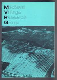
Medieval Village Research Group, Thirtieth annual report 1982
by edited by G I Meiron-Jones
- Used
- Paperback
- first
- Condition
- Used - Near Fine Condition
- Edition
- First Edition
- Binding
- Paperback
- Quantity Available
- 1
- Seller
-
Doncaster, Aberdeen, United Kingdom
- Item Price
-
CA$21.19CA$25.61 shipping to USA
Show Details
Description:
Medieval Village Research Group, 1982. First Edition. Softcover. Near Fine Condition/No Dust Jacket. ISSN 0260-5384. 40 pages. Crisp green covers, sound stapled binding, clean pages. Contents include: Obituary for Dr Margaret Davies, Dr Iorwerth C Peate; Research in 1982 - photographs, Fieldwork; Excavations; Interim Report of the Thirty-Third Season of the Wharram Research Project, North Yorkshire; Research in 1982 Overseas; The Development of Open-Area Excavation and its Introduction into Medieval Archaeology, an Historical Survey by Axel Steensberg; Deserted Medieval Villages in Slovakia, Some Recent Archaeological Research by Alojz Habovstiack; History and Medieval Village Studies by C Dyer, R Smith, and P D A Harvey; Emparking and the Desertion of Settlements in Hampshire by M F Hughes. No dust jacket, as published. Quantity Available: 1. Shipped Weight: under 1 kg. Pictures of this item not already displayed here available upon request. Inventory No: 40115111237. For international tracking…
Read More Item Price
CA$21.19
CA$25.61
shipping to USA

Didn’t find what you’re looking for?
Try adding this search to your want list. Millions of books are added to our site everyday and when we find one that matches your search, we’ll send you an email. Best of all, it’s free.
Add to Want List

Are you a frequent reader or book collector?
Join the Bibliophile's Club and save 10% on every purchase, every day — up to $20 savings per order!

Social Responsibility
Did you know that since 2004, Biblio has used its profits to build 16 public libraries in rural villages of South America?
