Description:
Philadelphia: Carey & Lea, 1827. 22 1/2 x 17 1/2 inches. Very good with discoloration in lower corners and two minor chips at the exterior. Please see pic.. Beautiful map from the first one-third of the 19th century. Three processes were used to complete this map. First the map was printed intaglio in black It was then printed letterpress for the text and external neatline. Then the map was finely handcolored.
Search Results: geographical historical and statistical map of
You searched for:
- Omit specific booksellers from results: The Prime Meridian: Antique Maps & Books, Argosy Book Store
- Title: geographical historical and statistical map of
- Author: carey lea
Results 1 - 20 of 27
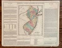
Geographical, Statistical, and Historical Map of New Jersey
by Carey, Henry & Isaac Lea
- Used
- Condition
- Used - Very good with discoloration in lower corners and two minor chips at the exterior. Please see pic.
- Quantity Available
- 1
- Seller
-
Franklin, Tennessee, United States
- Item Price
-
CA$104.62CA$8.37 shipping to USA
Show Details
Item Price
CA$104.62
CA$8.37
shipping to USA

Geographical, Statistical, and Historical Map of Columbia
by Carey & Lea
- Used
- Condition
- Used - Very good condition
- Quantity Available
- 1
- Seller
-
Franklin, Tennessee, United States
- Item Price
-
CA$132.52CA$8.37 shipping to USA
Show Details
Description:
Philadelphia: Carey & Lea, 1827. 20 3/4 x 16 1/2 inches. Very good condition. The is an early map of the country of Columbia as organized by the Congress of Cucuta, 1821 Simon Bolivar remained president. Bolivar was to become dictator soon after Included in the map are the provinces of New Grenada and Venezuela. The map is a snapshot of the areas transitional history. The description of the political landscape is found in the text. This is a very nice map for the regional historian.
Item Price
CA$132.52
CA$8.37
shipping to USA

Geographical, Statistical, and Historical Map of the United Provinces of South America
by Carey & Lea
- Used
- Condition
- Used - Very good condition
- Quantity Available
- 1
- Seller
-
Franklin, Tennessee, United States
- Item Price
-
CA$139.50CA$8.37 shipping to USA
Show Details
Description:
Philadelphia: Carey & Lea, 1827. 20 3/4 x 16 1/2 inches. Very good condition. his is a fine artifact of the mapmakers art covering current events in transitional countries in South America. The Map was pulled from a copperplate and hand colored at the time of publication. It was also printed in columns of text by a register process to ensure visual continuity. The map covers Argentina, Paraguay, Bolivia. The map for simplicities sake shows the 11 provinces as they existed in in 1810. The text explains the chief towns and their functions and goes on to describe commerce and government. finally the right hand column give a historical sketch of the area.
Item Price
CA$139.50
CA$8.37
shipping to USA

Geographical, Statistical, and Historical Map of Brazil
by Carey & Lea
- Used
- Condition
- Used - Very good condition
- Quantity Available
- 1
- Seller
-
Franklin, Tennessee, United States
- Item Price
-
CA$139.50CA$8.37 shipping to USA
Show Details
Description:
Philadelphia: Carey & Lea, 1827. 20 3/4 x 16 1/2 inches. Very good condition. Finely executed copperplate engraving colored at the time of publication. The text was added by letterpress to the columnar text was added by contemporary letterpress printing. The country was divided into 12 provinces or capitanias. The left column, upper half describes the location and physical geography. the bottom left column names the capitanias and points of the chief towns. Communications, commerce and religion lead the discussion of the government and the right column is comprised of a brief historical sketch of Brazil as known two centuries ago.
Item Price
CA$139.50
CA$8.37
shipping to USA

Geographical, Statistical and Historical Map of Kentucky
by Carey & Lea
- Used
- Condition
- Used
- Quantity Available
- 1
- Seller
-
Franklin, Tennessee, United States
- Item Price
-
CA$209.25CA$8.37 shipping to USA
Show Details
Description:
Philadelphia: Carey & Lea, 1827. 21 x 16 1/2 inches. This is the second edition of this map of Kentucky.
Item Price
CA$209.25
CA$8.37
shipping to USA

GEOGRAPHICAL, STATISTICAL, AND HISTORICAL MAP OF THE WEST INDIES.
by Carey, Henry Charles; Isaac Lea
- Used
- Paperback
- first
- Condition
- Used - Very good- condition
- Edition
- First Edition
- Binding
- Paperback
- Quantity Available
- 1
- Seller
-
Chicago, Illinois, United States
- Item Price
-
CA$244.12CA$8.37 shipping to USA
Show Details
Description:
Philadelphia, PA: Carey & Lea, 1822. Book. Very good- condition. Unbound. First Edition. 22.25" (width) x 17.5" (height) printed sheet, with 15.5" x 12.25" hand-colored map near center of sheet (four color). Nice condition, except for slight browning to center fold, which is offsetting from original glue from reverse hinge and overall minor browning of paper. An attractive image, suitable for office/library display or gift. Originally bound in an atlas titled "A Complete Historical, Chronological, and Geographical Atlas, Being A Guide to the History of North and South America, and the West Indies: Exhibiting an Accurate Account of the Discovery, Settlement, and Progress of their Various Kingdoms, States, Provinces, &c. Together with Wars, Celebrated Battles, and Remarkable Events, to the Year 1822. According to the Plan of LeSage's Atlas, and Intended as a Companion to Lavoisne's Improvement of that Celebrated Work." Americana..
Item Price
CA$244.12
CA$8.37
shipping to USA
More Photos
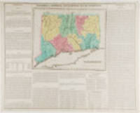
Connecticut. Geographical, Historic and Statistical Map of Connecticut
by CAREY, Henry Charles and Isaac LEA (publishers)
- Used
- Condition
- Used
- Quantity Available
- 1
- Seller
-
New York, New York, United States
- Item Price
-
CA$279.00FREE shipping to USA
Show Details
Description:
Philadelphia: Carey & Lea, 1823. Engraving with full period colour. Backed on linen. Split at fold expertly repaired. Occasional creases. Fascinating and informative map of Connecticut from one of the most innovative American atlases of the 19th century. Carey & Lea's atlas established a style that was widely admired, especially in Europe: placing a fully coloured map as the centerpiece of the page and surrounding it with geographical and historical facts. The texts were well written and intriguing. The immense transformation of continental America: the vast migration, settlement and industrialization really began at about this time, not long after the War of 1812, when expansion and opportunity were American by-words. It was at this time that American atlases began to need semi-annual revisions because the country had changed so rapidly. In fact, the Carey & Lea gazetteer style, most reminiscent of Herman Moll really, was too time consuming for the firms that published atlases of America as the…
Read More Item Price
CA$279.00
FREE shipping to USA

Geographical, Statistical, and Historical Map of Hispaniola, or St. Domingo
by [Hispaniola] Carey, Henry and Lea, Isaac
- Used
- Condition
- Used - Very good condition
- Quantity Available
- 1
- Seller
-
Garrison, New York, United States
- Item Price
-
CA$279.00CA$11.16 shipping to USA
Show Details
Description:
Philadelphia, 1823. Very good condition. Fine original engraved map of the island of Hispaniola (Haiti), from the first edition of Carey and Lea's 'A Complete Historical, Chronological, and Geographical American Atlas, being a Guide to the History of North and South America, and the West Indies . to the Year 1822', the best atlas of nineteenth century America. With the French part of the island, to the west, shown in pink and the Spanish part in yellow. With the history of unrest on the island described in the text below the map: "Hayti (sic) was recently divided into two distinct governments, under tow rival chiefs, president Petion, and king Christophe; the former, occupying the south-western part of the island, and the latter, the north western part. These chiefs are now both dead, and the island has become the theatre of new revolutions". A very vibrant, strong impression. Howe's C133. Image size: 20 3/4 x 16 1/2" on paper 22 1/4 x 17 1/2"
Item Price
CA$279.00
CA$11.16
shipping to USA

Geographical, Statistical, and Historical Map of Jamaica
by [Jamaica] Carey, Henry and Lea, Isaac
- Used
- Condition
- Used - Very good condition
- Quantity Available
- 1
- Seller
-
Garrison, New York, United States
- Item Price
-
CA$279.00CA$11.16 shipping to USA
Show Details
Description:
Philadelphia, 1823. Very good condition. Fine original engraved map of the island of Jamaica, from the first edition of Carey and Lea's 'A Complete Historical, Chronological, and Geographical American Atlas, being a Guide to the History of North and South America, and the West Indies . to the Year 1822', the best atlas of nineteenth century America. With Jamaican counties and parishes, and towns and harbors, including Kingston, Port Royal and Montego Bay. Under the text heading 'Civil Divisions and Population' is the following information on the number of slaves: "In 1812, there were 319,912 slaves, and the number of whites and free people of colour was estimated at 40,000". A very vibrant, strong impression. Howe's C133. Image size: 20 3/4 x 16 1/2" on paper 22 1/4 x 17 1/2"
Item Price
CA$279.00
CA$11.16
shipping to USA

More Photos
Geographical, Statistical, and Historical Map of Upper and Lower Canada, and the Other British Possessions in North America
by [Canada] Carey, Henry and Lea, Isaac
- Used
- Signed
- Condition
- Used - Very good condition
- Quantity Available
- 1
- Seller
-
Garrison, New York, United States
- Item Price
-
CA$348.75CA$11.16 shipping to USA
Show Details
Description:
Philadelphia, 1823. Very good condition. Fine original hand colored map of the British Empire in Canada, from the first edition of Carey and Lea's 'A Complete Historical, Chronological, and Geographical American Atlas, being a Guide to the History of North and South America, and the West Indies . to the Year 1822', the best atlas of nineteenth century America. The map extends from Newfoundland in the east to Lake of the Woods in the west; a very vibrant, strong impression. The text describes Lower Canada, Upper Canada, Nova Scotia and New Brunswick. With text below map and at both sides, pertaining to topography, climate, lands, towns, roads and canals, education, government and history. This map, according to History Detectives (Season 6, Episode 4: Lincoln Forgery) was evidently part of an Abraham Lincoln memorabilia scam in which a forger named Harry Sickles worked with Eugene Field II to pass off items in Field's collection as Lincoln items. Sickles and Field managed to convince William P.…
Read More Item Price
CA$348.75
CA$11.16
shipping to USA

Geographical, Statistical, and Historical Map of the West Indies
by [West Indies] Carey, Henry and Lea, Isaac
- Used
- Condition
- Used - Very good condition
- Quantity Available
- 1
- Seller
-
Garrison, New York, United States
- Item Price
-
CA$348.75CA$11.16 shipping to USA
Show Details
Description:
Philadelphia, 1823. Very good condition. Fine original hand colored map of the West Indies from the first edition of Carey and Lea's 'A Complete Historical, Chronological, and Geographical American Atlas, being a Guide to the History of North and South America, and the West Indies . to the Year 1822', the best atlas of nineteenth century America. Extending from the Bahamas and Cuba to Trinidad and Tobago, and showing many towns. With text on two sides and below map, pertaining to topography, climate, lands, towns & ports, government and history. Howes C133. Image size: 20 3/4 x 16 1/2" on paper 22 1/4 x 17 1/2"
Item Price
CA$348.75
CA$11.16
shipping to USA

More Photos
GEOGRAPHICAL, STATISTICAL, AND HISTORICAL MAP OF NEW HAMPSHIRE.
by Carey, Henry Charles; Isaac Lea
- Used
- Paperback
- first
- Condition
- Used - Very good+ condition
- Edition
- First Edition
- Binding
- Paperback
- Quantity Available
- 1
- Seller
-
Chicago, Illinois, United States
- Item Price
-
CA$418.50CA$8.37 shipping to USA
Show Details
Description:
Philadelphia, PA: Carey & Lea, 1822. Book. Very good+ condition. Unbound. First Edition. 22.25" (width) x 17.5" (height) printed sheet, with 8.75" x 11.75" hand-colored map near center of sheet (five color). Excellent condition, except for slight browning to center fold, which is offsetting from original glue from reverse hinge. Minor browning to margins of sheet, easily framed out. Small tear entering text, not affecting image or presentation. An attractive image, suitable for office/library display or gift. Originally bound in an atlas titled "A Complete Historical, Chronological, and Geographical Atlas, Being A Guide to the History of North and South America, and the West Indies: Exhibiting an Accurate Account of the Discovery, Settlement, and Progress of their Various Kingdoms, States, Provinces, &c. Together with Wars, Celebrated Battles, and Remarkable Events, to the Year 1822. According to the Plan of LeSage's Atlas, and Intended as a Companion to…
Read More Item Price
CA$418.50
CA$8.37
shipping to USA

More Photos
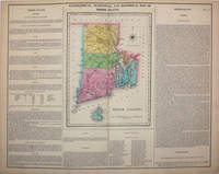
GEOGRAPHICAL, STATISTICAL, AND HISTORICAL MAP OF RHODE ISLAND.
by Carey, Henry Charles; Isaac Lea
- Used
- Paperback
- first
- Condition
- Used - Very good+ condition
- Edition
- First Edition
- Binding
- Paperback
- Quantity Available
- 1
- Seller
-
Chicago, Illinois, United States
- Item Price
-
CA$418.50CA$8.37 shipping to USA
Show Details
Description:
Philadelphia, PA: Carey & Lea, 1822. Book. Very good+ condition. Unbound. First Edition. 22.25" (width) x 17.5" (height) printed sheet, with 8.25" x 11.25" hand-colored map near center of sheet (five color). Excellent condition, except for slight browning to center fold, which is offsetting from original glue from reverse hinge. Minor browning to margins of sheet, easily framed out. An attractive image, suitable for office/library display or gift. Originally bound in an atlas titled "A Complete Historical, Chronological, and Geographical Atlas, Being A Guide to the History of North and South America, and the West Indies: Exhibiting an Accurate Account of the Discovery, Settlement, and Progress of their Various Kingdoms, States, Provinces, &c. Together with Wars, Celebrated Battles, and Remarkable Events, to the Year 1822. According to the Plan of LeSage's Atlas, and Intended as a Companion to Lavoisne's Improvement of that Celebrated Work." Americana..
Item Price
CA$418.50
CA$8.37
shipping to USA

More Photos
Geographical, Statistical, and Historical Map of Vermont
by [Vermont] Carey, Henry and Lea, Isaac
- Used
- Signed
- Condition
- Used - Very good condition
- Quantity Available
- 1
- Seller
-
Garrison, New York, United States
- Item Price
-
CA$418.50CA$11.16 shipping to USA
Show Details
Description:
Philadelphia, 1823. Very good condition. Fine original hand colored map of Vermont from the first edition of Carey and Lea's 'A Complete Historical, Chronological, and Geographical American Atlas, being a Guide to the History of North and South America, and the West Indies . to the Year 1822', the best atlas of nineteenth century America. Published just 10 years after the War of 1812, the map references the war: "During the last war with England, the vicinity of the state was the seat of a warm contest. On the invasion of New York, volunteers poured forth from the mountains and vallies (sic) of Vermont..." With text below map and at both sides, pertaining to topography, climate, lands, towns, roads and canals, education, government and history. This map, according to History Detectives (Season 6, Episode 4: Lincoln Forgery) was evidently part of an Abraham Lincoln memorabilia scam in which a forger named Harry Sickles worked with Eugene Field II to pass off items in Field's collection as Lincoln…
Read More Item Price
CA$418.50
CA$11.16
shipping to USA
More Photos
Geographical, Statistical, and Historical Map of Rhode Island
by [Rhode Island] Carey, Henry and Lea, Isaac
- Used
- Signed
- Condition
- Used - Very good condition
- Quantity Available
- 1
- Seller
-
Garrison, New York, United States
- Item Price
-
CA$418.50CA$11.16 shipping to USA
Show Details
Description:
Philadelphia, 1823. Very good condition. Fine original hand colored map of Rhode Island from the first edition of Carey and Lea's 'A Complete Historical, Chronological, and Geographical American Atlas, being a Guide to the History of North and South America, and the West Indies . to the Year 1822', the best atlas of nineteenth century America. By the 1820's Rhode Island was one of the most industrialized states; the text notes that there were more than 90 cotton mills established. Brown University is noted under 'Education': [It] is one of the most flourishing and respectable literary institutions ... in 1819 there were 126 students." With text below map and at both sides, pertaining to topography, climate, lands, towns, roads and canals, education, government and history. This map, according to History Detectives (Season 6, Episode 4: Lincoln Forgery) was evidently part of an Abraham Lincoln memorabilia scam in which a forger named Harry Sickles worked with Eugene Field II to pass off items in…
Read More Item Price
CA$418.50
CA$11.16
shipping to USA

Geographical, Statistical, and Historical Map of the Leeward Islands
by [Leeward Islands] Carey, Henry and Lea, Isaac
- Used
- Condition
- Used - Very good condition
- Quantity Available
- 1
- Seller
-
Garrison, New York, United States
- Item Price
-
CA$418.50CA$11.16 shipping to USA
Show Details
Description:
Philadelphia, 1823. Very good condition. Fine original hand colored map of the Leeward Islands (the northern islands of the Lesser Antilles chain, east of Puerto Rico and running southward to Dominica; they are named 'Leeward' because the prevailing winds blow from the east), from the first edition of Carey and Lea's 'A Complete Historical, Chronological, and Geographical American Atlas, being a Guide to the History of North and South America, and the West Indies . to the Year 1822', the best atlas of nineteenth century America. Extending from Anguilla in the north to Dominica in the south. With many towns and ports named, especially on Guadaloupe (Columbus named the island 'Santa María de Guadalupe' after the Virgin Mary) . A very vibrant, strong impression. With text below map and at both sides, pertaining to the geography and history of each island. Howe's C133. Image size: 20 3/4 x 16 1/2" on paper 22 1/4 x 17 1/2"
Item Price
CA$418.50
CA$11.16
shipping to USA

More Photos
Geographical, Statistical, and Historical Map of New York
by [New York] Carey, Henry and Lea, Isaac
- Used
- Signed
- Condition
- Used - Very good condition
- Quantity Available
- 1
- Seller
-
Garrison, New York, United States
- Item Price
-
CA$418.50CA$11.16 shipping to USA
Show Details
Description:
Philadelphia, 1823. Very good condition. Fine original hand colored map of New York from the first edition of Carey and Lea's 'A Complete Historical, Chronological, and Geographical American Atlas, being a Guide to the History of North and South America, and the West Indies to the Year 1822', the best atlas of 19th century America. This map was made during the construction of the Erie Canal, which had such an enormous impact on transportation, commerce and the role of New York City as the major US port; it is named here the Grand Canal. With a table at the base of the map titled "Profile of Levels of the Grand Canal", showing the change in levels of the Erie Canal from Lake Erie to the Hudson River. With text below map and at both sides, pertaining to topography, climate, lands, towns, roads and canals, education, government and history. This particular copy of the map has an interesting Lincoln forgery connection. According to History Detectives (Season 6, Episode 4: Lincoln Forgery) was evidently…
Read More Item Price
CA$418.50
CA$11.16
shipping to USA

More Photos
GEOGRAPHICAL, STATISTICAL, AND HISTORICAL MAP OF VERMONT.
by Carey, Henry Charles; Isaac Lea
- Used
- Paperback
- first
- Condition
- Used - Very good+ condition
- Edition
- First Edition
- Binding
- Paperback
- Quantity Available
- 1
- Seller
-
Chicago, Illinois, United States
- Item Price
-
CA$488.25CA$8.37 shipping to USA
Show Details
Description:
Philadelphia, PA: Carey & Lea, 1822. Book. Very good+ condition. Unbound. First Edition. 22.25" (width) x 17.5" (height) printed sheet, with 9.25" x 12" hand-colored map near center of sheet (five color). Excellent condition, except for slight browning to center fold, which is offsetting from original glue from reverse hinge. Minor browning to margins of sheet, easily framed out. A few tiny spots of staining to text, not affecting image. An attractive image, suitable for office/library display or gift. Originally bound in an atlas titled "A Complete Historical, Chronological, and Geographical Atlas, Being A Guide to the History of North and South America, and the West Indies: Exhibiting an Accurate Account of the Discovery, Settlement, and Progress of their Various Kingdoms, States, Provinces, &c. Together with Wars, Celebrated Battles, and Remarkable Events, to the Year 1822. According to the Plan of LeSage's Atlas, and Intended as a Companion to Lavoisne's…
Read More Item Price
CA$488.25
CA$8.37
shipping to USA

More Photos
Geographical, Statistical, and Historical Map of New Hampshire
by [New Hampshire] Carey, Henry and Lea, Isaac
- Used
- Signed
- Condition
- Used - Very good overall
- Quantity Available
- 1
- Seller
-
Garrison, New York, United States
- Item Price
-
CA$488.25CA$11.16 shipping to USA
Show Details
Description:
Philadelphia, 1823. Very good overall. Fine original hand colored map of New Hampshire from the first edition of Carey and Lea's 'A Complete Historical, Chronological, and Geographical American Atlas, being a Guide to the History of North and South America, and the West Indies . to the Year 1822', the best atlas of nineteenth century America. Under 'Education' the text notes: Phillips' s Exeter academy ... is one of the oldest and most flourishing academies in New England." With text below map and at both sides, pertaining to topography, climate, lands, towns, roads and canals, education, government and history. This map, according to History Detectives (Season 6, Episode 4: Lincoln Forgery
Item Price
CA$488.25
CA$11.16
shipping to USA

More Photos
Geographical, Statistical, and Historical Map of Massachusetts
by [Massachusetts] Carey, Henry and Lea, Isaac
- Used
- Signed
- Condition
- Used - Very good condition
- Quantity Available
- 1
- Seller
-
Garrison, New York, United States
- Item Price
-
CA$523.12CA$11.16 shipping to USA
Show Details
Description:
Philadelphia, 1823. Very good condition. Fine original hand colored map of Massachusetts from the first edition of Carey and Lea's 'A Complete Historical, Chronological, and Geographical American Atlas, being a Guide to the History of North and South America, and the West Indies . to the Year 1822', the best atlas of nineteenth century America. With a long text description titled 'Peninsulas, Islands and Capes' describing Cape Cod, Cape Anne, Martha's Vineyard, Nantucket, and the Elizabeth Islands. With text below map and at both sides, pertaining to topography, climate, lands, towns, roads and canals, education, government and history. This map, according to History Detectives (Season 6, Episode 4: Lincoln Forgery) was evidently part of an Abraham Lincoln memorabilia scam in which a forger named Harry Sickles worked with Eugene Field II to pass off items in Field's collection as Lincoln items. Sickles and Field managed to convince William P. Brown, the still living coachman of Abraham Lincoln, that…
Read More Item Price
CA$523.12
CA$11.16
shipping to USA

Didn’t find what you’re looking for?
Try adding this search to your want list. Millions of books are added to our site everyday and when we find one that matches your search, we’ll send you an email. Best of all, it’s free.
Add to Want List

Are you a frequent reader or book collector?
Join the Bibliophile's Club and save 10% on every purchase, every day — up to $20 savings per order!

Social Responsibility
Did you know that since 2004, Biblio has used its profits to build 16 public libraries in rural villages of South America?
