Skip to content

Item Added!

1 item in your Cart

Subtotal: CA$832.98


Your Cart Items

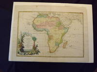
L' Afrique Divisee En Ses Principaux Etats

L' Afrique Divisee En Ses Principaux Etats

Janvier, Sieur Jean.
Book Condition
Used
Seller
About Item
Engraved, hand colored, decorative cartouche, ample margins, 43.7 x 30 cm (17 1/2" x 12"). Minor aging and slight browning; otherwise very good, bright and with a strong impression. Janivier was a French geographer that was active in the second half of the 18th century. According to Norwich and Tooley, Janivier produced a series of maps in 1760, and collaborated in an Atlas Moderne in 1762 and 1771.The present map is number 28 from that atlas. This rather handsome engraved map, which has full color, appears to present the cartographic knowledge of Africa in the mid 18th century. The map is fairly accurate, and shows the only settlements in southern Africa, and also features a few Hottentot tribes. The cartouche, which is in the lower left part of the map, shows a few tress, a leopard stalking, and a crocodile near the bottom. Norwich 104. Tooley p. 59.
Quantity
1
Item Price
CA$832.98
Standard shipping to USA: CA$11.11,
7 to 14 days for delivery
Save 10% on all books!

Join the Bibliophiles Club

Save 10% on this and every purchase — up to $20 savings per order! Membership is only $29.95/year.

Order Summary

Subtotal: CA$832.98
Shipping: CA$11.11
Total: CA$844.09
Tax (if applicable) calculated at checkout.

Payment Methods Accepted

  • Visa
  • Mastercard
  • American Express
  • Discover
  • Paypal

Verified and Secured. Guaranteed.

Website Secured with 256-bit TLS Encryption
Promo Code
tracking-