Skip to content

Item Added!

1 item in your Cart

Subtotal: CA$173.09


Your Cart Items

Karte von dem Morgenlaendischen Ocean oder dem Indischen Meere. Zur allgemeinen Historie der...
More Photos

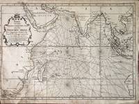
Karte von dem Morgenlaendischen Ocean oder dem Indischen Meere. Zur allgemeinen Historie der Reisebeschreibungen entworfen. Von Hrn. Bellin Ing. de la Marine.

Bellin (Jacques-Nicolas) [Nicolaus] (Published by: Johann Joachim Schwabe)
Book Condition
Used
Seller
About Item
Leipzig: Arkstee und Merkus, 1748.. A copper engraved map on laid paper, uncoloured, from Volume 2 of Schwabe's Allgemeine Historie der Reisen (1748 - 1774). Decorative cartouche in upper left. Image size is 47cm x 34cm. Text in German. Verso blank. In upper right corner: "Zusatz zum 1 Bande 3e Karte.". Original folds, very good condition, old tape repair on verso at lower left. Trimmed to the plate line on the left edge. From Bellin's French map (Carte De L'Ocean Oriental ou Mer Des Indes.... ) published in Prevost's L'Histoire Generale des Voyages (Volume 3, 1747). The German edition of Bellin's map of the Indian Ocean, with the eastern coasts of South Africa, India, Indochina, parts of the East Indies and the Western coast of Australia.
Quantity
1
Item Price
CA$173.09
Standard shipping to USA: CA$24.92,
6 to 12 days for delivery
Save 10% on all books!

Join the Bibliophiles Club

Save 10% on this and every purchase — up to $20 savings per order! Membership is only $29.95/year.

Order Summary

Subtotal: CA$173.09
Shipping: CA$24.92
Total: CA$198.01
Tax (if applicable) calculated at checkout.

Payment Methods Accepted

  • Visa
  • Mastercard
  • American Express
  • Discover
  • Paypal

Verified and Secured. Guaranteed.

Website Secured with 256-bit TLS Encryption
Promo Code
tracking-