Description:
[Tavernier], 1636. Print. Near Fine. Matted and ready for framing. Untrimmed. An exceptional example of a scarce print. A 7 x 9 3/4 sheet professionally matted down to 4 3/4 x 6 3/4 (mat measures 8 1/2 x 10 5/8). Beautiful modern hand coloring added. Labeled 20 in the upper right-hand corner. The print shows a fortification positioned on the north side of a natural waterway, with a small fortification on the opposite side as well. A bridge links the main fortification to the opposite shore, and there appears to be an area for entry by boat along the south wall. This fortress is unique in being completely surrounded by water - the river water acts as a moat between the inner and outer curtains, and also as a moat outside the outer curtain. The only land entries are the south bridge gate and a northern gate that passes through the outer curtain. The shapes of the walls illustrate the star-shaped patterns common to this era, an adaptation made to allow for defensive canonry, and to protect against…
Read More Search Results: hand colored 1636 print map of
You searched for:
- Title: hand colored 1636 print map of
- Author: tassin nicholas
Results 1 - 3 of 3
![Hand Colored 1636 Print, Map of St Iean de lauen [St Jean delaune], from 'Les plans et...](https://d3525k1ryd2155.cloudfront.net/h/841/205/477205841.0.m.1.jpg)
Hand Colored 1636 Print, Map of St Iean de lauen [St Jean delaune], from 'Les plans et profils de toutes les principales villes et lieux considerables de France
by [Tassin, Nicholas]
- Used
- near fine
- Condition
- Used - Near Fine
- Quantity Available
- 1
- Seller
-
Webster, New York, United States
- Item Price
-
CA$41.49CA$8.56 shipping to USA
Show Details
Item Price
CA$41.49
CA$8.56
shipping to USA
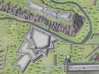
Hand Colored 1636 Print, Map of Roquecourbe, from 'Les plans et profils de toutes les principales villes et lieux considerables de France
by [Tassin, Nicholas]
- Used
- near fine
- Condition
- Used - Near Fine
- Quantity Available
- 1
- Seller
-
Webster, New York, United States
- Item Price
-
CA$41.49CA$8.56 shipping to USA
Show Details
Description:
[Tavernier], 1636. Print. Near Fine. Matted and ready for framing. Untrimmed. An exceptional example of a scarce print. A 7 x 9 3/4 sheet professionally matted down to 4 3/4 x 6 3/4 (mat measures 8 1/2 x 10 5/8). Beautiful modern hand coloring added. Labeled 44 in the upper right-hand corner. Roquecourbe is a region in south central France. The print shows a unique two-part fortification positioned on both sides of a natural waterway. The larger part borders on the south, with a bridge gatehouse leading to the main road. The northern portion sits atop a plateau linked to the main road by a winding stair. Attacking forces attempting to storm the main gate would be caught in a pincer attack between the two fortresses. The limited space between river and plateau would put them at even more severe a disadvantage by reducing troops to a narrow column. The shapes of the walls illustrate the star-shaped patterns common to this era, an adaptation made to allow for defensive canonry, and to protect against…
Read More Item Price
CA$41.49
CA$8.56
shipping to USA
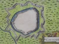
Hand Colored 1636 Print, Map of Caussade, from 'Les plans et profils de toutes les principales villes et lieux considerables de France
by [Tassin, Nicholas]
- Used
- near fine
- Condition
- Used - Near Fine
- Quantity Available
- 1
- Seller
-
Webster, New York, United States
- Item Price
-
CA$41.49CA$8.56 shipping to USA
Show Details
Description:
[Tavernier], 1636. Print. Near Fine. Matted and ready for framing. Untrimmed. An exceptional example of a scarce print. A 7 x 9 3/4 sheet professionally matted down to 4 3/4 x 6 3/4 (mat measures 8 1/2 x 10 5/8). Beautiful modern hand coloring added. Labeled 15 in the upper right-hand corner. Caussade is a region in southwestern France. The print shows a fortification positioned along a waterway which runs northwest to southeast along the southwest wall. The only entrance is at the northeast corner. There are two curtain walls, the inner one surrounded by a moat. The shapes of the walls illustrate the star-shaped patterns common to this era, an adaptation made to allow for defensive canonry, and to protect against siege artillery.
Item Price
CA$41.49
CA$8.56
shipping to USA

Didn’t find what you’re looking for?
Try adding this search to your want list. Millions of books are added to our site everyday and when we find one that matches your search, we’ll send you an email. Best of all, it’s free.
Add to Want List

Are you a frequent reader or book collector?
Join the Bibliophile's Club and save 10% on every purchase, every day — up to $20 savings per order!

Social Responsibility
Did you know that since 2004, Biblio has used its profits to build 16 public libraries in rural villages of South America?
