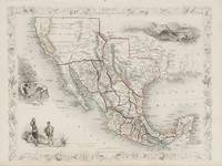
Description:
London: The London Printing and Publishing Company, [1851-1856].. Original steel-engraved decorative map (36 x 28 cm). With three vignettes by H. Warren, including Ruins at Uxmal. Yucatan, Mexican Peasantry, and Gold Washing. Decorative scrolling and title cartouche around the edges of the maps. Original outline colour. Centrefold crease as issued. An excellent example. Shows the "The newly discovered GOLD districts..." coloured in yellow in California. For the Great Exhibition in 1851 John Tallis (1817-1876) worked with engraver John Rapkin (1815-1876) to publish the 'Illustrated World Atlas', whose maps were later re-issued by the London Printing and Publishing Company. Their maps are prized for their wonderful steel-engraved vignettes showing the peoples, customs, architecture, landmarks, flora, and fauna of each country.
Search Results: mexico california and texas
You searched for:
- Title: mexico california and texas
- Author: tallis john
Results 1 - 5 of 5

Mexico, California and Texas.
by RAPKIN, J. [TALLIS, John].
- Used
- Condition
- Used
- Quantity Available
- 1
- Seller
-
London, London, United Kingdom
- Item Price
-
CA$434.32CA$15.55 shipping to USA
Show Details
Item Price
CA$434.32
CA$15.55
shipping to USA

Mexico, California and Texas.
by RAPKIN, J. [TALLIS, John].
- Used
- Condition
- Used
- Quantity Available
- 1
- Seller
-
London, London, United Kingdom
- Item Price
-
CA$434.32CA$15.55 shipping to USA
Show Details
Description:
London, Edinburgh, & Dublin: J. & F. Tallis, [1851-1856].. Original steel-engraved decorative map (36 x 28 cm). With three vignettes by H. Warren, including Ruins at Uxmal. Yucatan, Mexican Peasantry, and Gold Washing. Decorative scrolling and title cartouche around the edges of the maps. Original outline colour. Some faint toning and soiling to margins, centrefold crease as issued, generally very good. Shows the "The newly discovered GOLD districts..." coloured in yellow in California. For the Great Exhibition in 1851 John Tallis (1817-1876) worked with engraver John Rapkin (1815-1876) to publish the 'Illustrated World Atlas', whose maps were later re-issued by the London Printing and Publishing Company. Their maps are prized for their wonderful steel-engraved vignettes showing the peoples, customs, architecture, landmarks, flora, and fauna of each country.
Item Price
CA$434.32
CA$15.55
shipping to USA

Mexico, California and Texas.
by RAPKIN, J. [TALLIS, John].
- Used
- Condition
- Used
- Quantity Available
- 1
- Seller
-
London, London, United Kingdom
- Item Price
-
CA$521.19CA$15.55 shipping to USA
Show Details
Description:
London, Edinburgh & Dublin. J & F Tallis. [c. 1856]. 25 x 32.5 cm. Original outline colour. Steel engraved map. With three vignettes, including one of gold panning. Decorative scrolling and title cartouche around the edges of the maps. Very good. Shows the "The newly discovered GOLD districts.." coloured in yellow in California. For the Great Exhibition in 1851 John Tallis (1817-1876) worked with engraver John Rapkin (1815-1876) to publish the 'Illustrated World Atlas', whose maps were later re-issued by the London Printing and Publishing Company under the Tallis imprint. Their maps are prized for their wonderful steel-engraved vignettes showing the peoples, customs, architecture, landmarks, flora, and fauna of each country.
Item Price
CA$521.19
CA$15.55
shipping to USA

Mexico, California and Texas.
by RAPKIN, J. [TALLIS, John].
- Used
- Condition
- Used
- Quantity Available
- 1
- Seller
-
London, London, United Kingdom
- Item Price
-
CA$521.19CA$15.55 shipping to USA
Show Details
Description:
The London Printing and Publishing Company, [1851-1856].. Original steel engraved map (36 x 28 cm). With three vignettes, including Ruins at Uxmal. Yucatan, Mexican Peasantry, and Gold Washing. Decorative scrolling and title cartouche around the edges of the maps. Original outline colour. Centrefold crease as issued. Very good condition. Shows the "The newly discovered GOLD districts.." coloured in yellow in California. For the Great Exhibition in 1851 John Tallis (1817-1876) worked with engraver John Rapkin (1815-1876) to publish the 'Illustrated World Atlas', whose maps were later re-issued by the London Printing and Publishing Company. Their maps are prized for their wonderful steel-engraved vignettes showing the peoples, customs, architecture, landmarks, flora, and fauna of each country.
Item Price
CA$521.19
CA$15.55
shipping to USA
More Photos
Mexico, California and Texas with Vignettes and illustrations of the Ruins at Uxmal on the Yucatan Peninsula, Mexican Peasantry, Gold Washing. Showing also the gold districts of California which subsequently led to the Gold Rush.
by America / Central America / Latin America / Mexico - Tallis, John / Rapkin, John. (1817 - 1876)
- Used
- Condition
- Used
- Quantity Available
- 1
- Seller
-
Skibbereen, Ireland
- Item Price
-
CA$564.95CA$57.98 shipping to USA
Show Details
Description:
1851. London & New York, J & F. Tallis, 1851. Original steel engraving / Vintage map. Drawn and engraved by John Rapkin. Partly hand-coloured. Plate Size: 33 cm x 25 cm. Sheet Size: 37.6 cm x 27.3 cm. Vintage 19th century map in very good condition. John Tallis (7 November 1817 3 June 1876) was an English cartographic publisher. His company, John Tallis and Company, published views, maps and atlases in London from roughly 1838 to 1851. Tallis set up as a publisher with Frederick Tallis in Cripplegate in 1842; the business moved to Smithfield in 1846, and was dissolved in 1849. From 1851 to 1854 Tallis operated as John Tallis and Company. He started The illustrated news of the world and national portrait gallery of eminent personages in 1858, selling it for £1,370 in 1861; it folded in 1863. (Wikipedia) The most important project John Tallis undertook, was the 'Illustrated Atlas' from 1851. The original map we offer here, was part of this exceptional Atlas and all the maps it contained are still…
Read More Item Price
CA$564.95
CA$57.98
shipping to USA

Didn’t find what you’re looking for?
Try adding this search to your want list. Millions of books are added to our site everyday and when we find one that matches your search, we’ll send you an email. Best of all, it’s free.
Add to Want List

Are you a frequent reader or book collector?
Join the Bibliophile's Club and save 10% on every purchase, every day — up to $20 savings per order!

Social Responsibility
Did you know that since 2004, Biblio has used its profits to build 16 public libraries in rural villages of South America?
