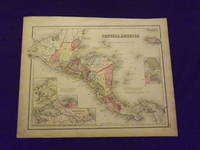
Description:
Unbound, colored engraved map, decorative boarder, double page 16"x 13". Slight toning, darkening and aging; overall bright and clean and in very good condition. Maps are wrapped with acid free board, or in rigid sleeves. Beginning with J. H. Colton (1800-1893), the Colton family published atlases for over 30 years. Colton's Atlas of the World was first published in 1855 in a large two volume set. In 1857 it became Colton's General Atlas, and Colton's sons, George Woolworth and Charles B. would take over the business. This map of Central America is probably from the 1857 edition of Colton's General Atlas, even though the copyright date on the map indicates 1855. This page map is fairly colorful, and has a couple of small inset maps, including one of the Isthmus of Panama. Ristow 313-326.
Search Results: central america
You searched for:
- Title: central america
- Author: colton j h
Results 1 - 4 of 4
Colton's Map of Central America.
by Colton, J.H.
- Used
- Condition
- Used
- Quantity Available
- 1
- Seller
-
Florham Park, New Jersey, United States
- Item Price
-
CA$117.56CA$11.06 shipping to USA
Show Details
Item Price
CA$117.56
CA$11.06
shipping to USA

Central America
by COLTON, J.H.
- Used
- Condition
- Used
- Quantity Available
- 1
- Seller
-
New York, New York, United States
- Item Price
-
CA$200.54CA$8.30 shipping to USA
Show Details
Description:
New York: J.H. Colton & Co, 1857. unbound. Map. Engraving with original hand coloring. Image measures 14 3/4" x 18 1/8".<br/> <br/> Handsome map of Central America. Features several insets depicting the Isthmus of Panama, the "Nicaragua Route", and the harbor of San Juan de Nicaragua, as well as grid plans of the City of Panama, and Aspinwall City on the island of Manzanilla. Extensively labeled with cities, coastal features and islands, major rivers, regions, and native populations. The Panama railroad is depicted, as well as the proposed "Honduras Interoceanic Railway" is shown from Puerto Caballos to the Gulf of Fonseca. Published in 1857, the map is surrounded by a simple line border. In very good condition, with minor chips to margins not affecting the image.<br> <Br> The Colton family was one the most prolific and successful publishers of maps and atlases in the United States. J.H. Colton (1800-1893) founded his business in NYC in…
Read More Item Price
CA$200.54
CA$8.30
shipping to USA

MAP: "Johnson's Map of Central America (1861)'...from Johnson's New Illustrated (Steel Plate) Family Atlas, 1861
by Colton, J.H. & Johnso, A.J. (compiled, Drawn & Engraved by)
- Used
- very good
- Paperback
- first
- Condition
- Used - Very Good
- Edition
- 1st
- Binding
- Paperback
- Quantity Available
- 1
- Seller
-
Hagerstown, Maryland, United States
- Item Price
-
CA$207.45CA$9.96 shipping to USA
Show Details
Description:
Richmond, VA: Johnson & Browning, 1861. Plate #57; lovely hand-colored map; of Mexico at the beginning of the Civil War, decorative strapwork border; w/ Counties, cities, roads, rivers, railroads, wagon roads,canals, ports, etc w/insets of ;Isthmus of Panama; the Niacarague Route, the Ccity of Panama; Aspinwall City & Navy Bay. . 1st. Unbound. Very Good. Illus. by Handcolored Illustrations. 17" x 13.5".
Item Price
CA$207.45
CA$9.96
shipping to USA

Central America
by COLTON, J.H.
- Used
- Condition
- Used
- Quantity Available
- 1
- Seller
-
New York, New York, United States
- Item Price
-
CA$276.60CA$8.30 shipping to USA
Show Details
Description:
New York: J.H. Colton & Co, 1856. unbound. Map. Engraving with original hand coloring. Image measures 14 3/4" x 18 1/8".<br/> <br/> Decorative and informative map of Central America. Features several insets depicting the Isthmus of Panama, the "Nicaragua Route", and the harbor of San Juan de Nicaragua, as well as grid plans of the City of Panama, and Aspinwall City on the island of Manzanilla. Extensively labeled with cities, coastal features and islands, major rivers, regions, and native populations. The Panama railroad is depicted, as well as the proposed "Honduras Interoceanic Railway" is shown from Puerto Caballos to the Gulf of Fonseca. Colton's signature strap-work border surrounds the map. in very good condition. One closed tear to lower margin, not affecting the image.<br> <Br> The Colton family was one the most prolific and successful publishers of maps and atlases in the United States. J.H. Colton (1800-1893) founded his business…
Read More Item Price
CA$276.60
CA$8.30
shipping to USA

Didn’t find what you’re looking for?
Try adding this search to your want list. Millions of books are added to our site everyday and when we find one that matches your search, we’ll send you an email. Best of all, it’s free.
Add to Want List

Are you a frequent reader or book collector?
Join the Bibliophile's Club and save 10% on every purchase, every day — up to $20 savings per order!

Social Responsibility
Did you know that since 2004, Biblio has used its profits to build 16 public libraries in rural villages of South America?
