Description:
full
A Map of the British Empire in America with the French, Spanish and the Dutch Settlements adjacent thereto by POPPLE, Henry (d. 1743) - Johannes COVENS (1697-1774) & Cornelius MORTIER (1697-1783), publishers - 1742
by POPPLE, Henry (d. 1743) - Johannes COVENS (1697-1774) & Cornelius MORTIER (1697-1783), publishers

A Map of the British Empire in America with the French, Spanish and the Dutch Settlements adjacent thereto
by POPPLE, Henry (d. 1743) - Johannes COVENS (1697-1774) & Cornelius MORTIER (1697-1783), publishers
- Used
Amsterdam: printed for John Covens and Cornelius Mortier, 1742. Copper-engraved map on four sheets, key map, sheet of harbor maps all hand-coloured in outline; 4 engraved views of Quebec, New York, Niagara Falls. Seven sheets, each 26 x 21 1/2 inches. An important association copy of the Covens and Mortier edition of the famous Popple map, annotated by Peter Wraxall: a man intimately associated with the establishment and setting of boundaries in colonial America. Henry Popple produced this map under the auspices of the Lord Commissioners of Trade and Plantations to help settle disputes arising from the rival expansions of English, Spanish and French colonies. "France claimed not only Canada, but also territories drained by the Mississippi and its tributaries - in practical terms, an area of half a continent" (Goss The Mapping of North America p.122.) The thrust of British mapmaking after 1718 was to establish her presence cartographically on the French. Hence the title "The British Empire in America..."Nevertheless, in making the map, Popple used the best available geographical information: Colonel Barnwell's map of the southeast; De L'Isle's "Carte de la Louisiane"; Cadwallader Colden's map of the Iroquois nations, and seems to have come up with a map that did not please imperialistic British viewers as much as it did those who only wanted an accurate depiction. The result was and is a vast map of North America never before delineated in such detail, and a source of delight and intrigue. The map was eventually very successful and there were several editions. Babinksi notes that George Washington owned a copy of the Key map (Popple's abbreviated version) and Benjamin Franklin ordered two copies for the Pennsylvania Assembly in 1746 and another in 1752. The Popple and Mitchell (1755) maps were the most important maps of North America made in the 18th century and were widely known and referred to throughout the formation of the United States. This example is the second state of the edition published by Covens and Mortier in Amsterdam, circa 1742. Covens & Mortier was a highly respected Amsterdam map publishing firm, which, more than any of their colleagues, maintained the high standards established by the Dutch and French cartographers of the previous century. The seven page Popple map appeared in the Covens & Mortier edition of De l'Isle's Atlas Nouveau . The Covens and Mortier version of Popple offers in a rather more manageable and accessible form all the geographical and political material of the original, including the depiction of Wager's sea battle with the Spanish near Cartagena in 1707. The region in question, the Eastern half of North America and a portion of northern South America, is laid out on four sheets, which joined would be roughly 43 x 52 inches. Each sheet is titled with its content. In addition to this are three more sheets: the Key map, a sheet with four views: Mexico City, New York, Quebec and Niagara Falls, and a sheet with eighteen harbor and island plans from Annapolis Royal in Nova Scotia to Porto Bello in Panama. It is unusual to have the Key map, as it was frequently separated from the others and framed by itself. This copy is further individualized in that it is the Wraxall-Dunkin-Van Rensslaer copy. It originally belonged to and was annotated by Peter Wraxall (d. 11 July 1759). He was an Englishman, who settled in New York and became involved in the relations between the Colony and the Iroquois Confederacy, which was a critical element in Britain's rivalry with France, writing several reports on the history of relations between whites and Iroquois in New York. Wraxall was William Johnson's secretary and, in battle, aide-de-camp, for the first two years of the French and Indian War. The atlas from which this map was removed subsequently passed to Elizabeth Dunkin (d.1846, niece of Wraxall's wife Elizabeth), who gave it to her son-in-law John Sanders Van Rensslaer (1792-1868). Wraxall limits his annotations to the upper left sheet; he notes in the lower left corner of the margin that the so-called 'Lake Illinois' "in the Maps published by Jefferies 19th Feby. 1753 this Lake is named Mishigan & he runs the limits of the 6 Nations to the Branch of the Missisipi called in the above Map River Msingona". In addition he has added a sub-title (Native American name) to Lake Erie. Mark Babinski Henry Popple's 1733 map (New Jersey, 1998) (ref); Cumming, The Southeast in Early Maps 249; E. McSherry Fowble Two Centuries of Prints in America 1680-1880 (1987), 6, 7; cf. John Goss The Mapping of North America (1990) 55 (key map only); Graff 3322; Howes P481, "b"; Lowery 338; McCorkle, et al. America Emergent 21; McCorkle, New England 741.3; Phillips Maps 569; Sabin 64140; Schwartz & Ehrenberg p.151; Streeter Sale 676; Stephenson & McKee Virginia in Maps , map II-18A-B; American National Biography.
-
Seller
Donald Heald Rare Books
 (US)
(US)
- Book Condition Used
- Quantity Available 1
- Publisher printed for John Covens and Cornelius Mortier
- Place of Publication Amsterdam
- Date Published 1742
- Keywords 18th century

Attempt on Roosevelt Life
by nebraska state journal
- Used
- Condition
- Used
- Quantity Available
- 1
- Seller
-
Lincoln, Nebraska, United States
- Item Price
-
CA$13.84
Show Details
Item Price
CA$13.84

Cap'n Kid Goes To The South Pole
by Engle, Joanna
- Used
- good
- Paperback
- first
- Condition
- Used - Good
- Jacket Condition
- None Issued
- Edition
- First Edition
- Binding
- Paperback
- ISBN 10 / ISBN 13
- 9780394856438 / 0394856430
- Quantity Available
- 1
- Seller
-
Salem, Oregon, United States
- Item Price
-
CA$27.69CA$13.84Save CA$10.00!
Show Details
Description:
Engle, Joanna. Cap'n Kid Goes To The South Pole. A Seaworld Adventure featuring Shamu, the Killer Whale. RARE. Children's Book. Used. Good, clean Condition. Softcover. Stapled binding. Random House copyright 1983. 5 ½ X 5. ISBN 0394856430. Original cover price $1.25.
Item Price
CA$27.69CA$13.84
Save CA$10.00
!

The Treasure Of Sierra Madre
by Traven, B
- Used
- Hardcover
- first
- Condition
- Used - Good-
- Jacket Condition
- No DJ Included
- Edition
- Large-Print Edition
- Binding
- Hardcover
- ISBN 10 / ISBN 13
- 9780786201006 / 0786201002
- Quantity Available
- 1
- Seller
-
Salem, Oregon, United States
- Item Price
-
CA$46.92CA$23.47Save CA$16.94!
Show Details
Description:
Traven, B. : The Treasure Of Sierra Madre. 1994 THORNDIKE PRESS LARGE-PRINT EDITION. Thorndike, Maine. EXLIB. Good/ No DJ if issued. ISBN0786201002. 533 pages. 5 ¾ X 8 ¾. Summary: "The story of three American adventurers who search for a lost gold mine in the mountains of Mexico. A tale of 'gold fever' and desperate greed." Basis for the Humphrey Bogart, John Houston film of the same name.
Item Price
CA$46.92CA$23.47
Save CA$16.94
!
More Photos
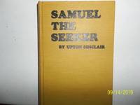
Samuel The Seeker
by Sinclair, Upton
- Used
- very good
- Hardcover
- first
- Condition
- Used - Very Good
- Jacket Condition
- No DJ Included
- Edition
- First Edition
- Binding
- Hardcover
- Quantity Available
- 1
- Seller
-
Salem, Oregon, United States
- Item Price
-
CA$55.38CA$27.69Save CA$20.00!
Show Details
Description:
Sinclair, Upton. Samuel, The Seeker Copyright 1910. Apparently published by author. No publisher stated. First Edition. States printed at Western Printing and Lithography, Racine, WI. Yellow Boards with black titling. Used. Very Good/ No Dj is Included. Rare/Scarce. A nice copy.
Item Price
CA$55.38CA$27.69
Save CA$20.00
!

Oregon; Or, a Short History of a Long Journey: Narrative of a Journey Across the Rocky Mountains, to the Columbia River
by John B. Wyeth
- Used
- very good
- Hardcover
- Condition
- Used - Very Good
- Edition
- Limited Edition
- Binding
- Hardcover
- Quantity Available
- 1
- Seller
-
Longmont, Colorado, United States
- Item Price
-
CA$27.69
Show Details
Description:
YE Gallon Press, 1970. Limited Edition. #499/605. VG. Interior is tight, clean, and free of ownership marks except for one penciled notation on the flyleaf. Cloth boards show shelf and handling wear with light soiling, edge, corner, and spine wear. Overall a solid copy showing minimal signs of use. Photo is of the copy we have here at Barbed Wire Books.
Item Price
CA$27.69
More Photos
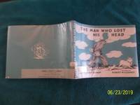
The Man Who Lost His Head
by Claire Huchet Bishop
- Used
- very good
- Hardcover
- Condition
- Used - Very Good
- Jacket Condition
- Very Good
- Edition
- Reprint Edition
- Binding
- Hardcover
- Quantity Available
- 1
- Seller
-
Salem, Oregon, United States
- Item Price
-
CA$62.15CA$31.08Save CA$22.44!
Show Details
Description:
The Man Who Lost His Head. By Claire Huchet Bishop. Viking Press, Copyright Renewed 1970. 16th Impression thus. Exlib. VG/VG unclipped DJ. Original cover price $3.56. Wrap-around blue and white endpapers show a headless man walking past farm animals on his way to the fair to look for his head there. Pages are bright. Now protected in a mylar wrap. A fantasy illustrated by Robert McCloskey, author and illustrator of "Make Way For Ducklings". Summary: "A man wakes up to find that he has no head, so he goes looking for it." Hard title to find.
Item Price
CA$62.15CA$31.08
Save CA$22.44
!

More Photos
Lucky You, What Science Has Done For Us
by Leaf, Munro
- Used
- good
- Hardcover
- first
- Condition
- Used - Good
- Jacket Condition
- Good
- Edition
- Stated First Edition
- Binding
- Hardcover
- Quantity Available
- 1
- Seller
-
Salem, Oregon, United States
- Item Price
-
CA$62.30CA$31.15Save CA$22.50!
Show Details
Description:
Lucky You: What Science Has Done For Us J.B. Lippincott Stated First Edition. SCIENCE. Artfully illustrated by MUNRO LEAF. Good EXLIB in a Good unclipped $2.25 orig. price dust jacket. Last page states: 152 4.
Item Price
CA$62.30CA$31.15
Save CA$22.50
!
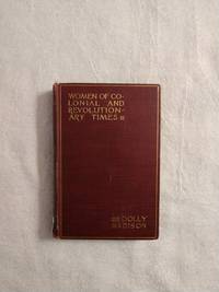
DOLLY MADISON: WOMEN OF COLONIAL AND REVOLUTIONARY TIMES
by Goodwin, Maud Wilder
- Used
- good
- Hardcover
- first
- Condition
- Used - Good
- Edition
- First Edition
- Binding
- Hardcover
- Quantity Available
- 1
- Seller
-
Buffalo, Wyoming, United States
- Item Price
-
CA$38.07
Show Details
Description:
New York: Charles Scribner's Sons, 1886. First Edition . Hardcover. Good. 12mo - over 6¾" - 7¾" tall. Book is in G condition with light rubbing to edges, cocked spine, bumping & fraying to spine ends, pencil marking to FFE, owner's name to title page, a couple of small tears to title page else still a bright and solid copy. SA 6/21
Item Price
CA$38.07

More Photos
Grant Wood and Marvin Cone : Artists of an Era
by Hazel E. Brown
- Used
- near fine
- Hardcover
- Signed
- first
- Condition
- Used - Near Fine
- Jacket Condition
- Very Good
- Edition
- First Edition
- Binding
- Hardcover
- ISBN 10 / ISBN 13
- 9780813817750 / 0813817757
- Quantity Available
- 1
- Seller
-
Arlington, Virginia, United States
- Item Price
-
CA$38.69
Show Details
Description:
Ames: Iowa State University Press, 1972. Hardcover. First Edition (stated). Flat signed and dated by author on FFEP and Inscribed by author to a friend on half-title page. Near Fine book in a Very Good jacket. Interior pristine except for author's inscription and signature. Spine straight and tight. Jacket shows light rubbing, light chipping at spine head, and light reading wear to edges. Not from a library. No remainder mark. Not clipped. xi + 150 pages. illus. A reflection of the relationships of two artists -- Grant Wood (1891-1942) and Marvin Cone (1891-1965) -- with the community of Cedar Rapids, Iowa. A loving biography by a woman who knew them both. Laid-in are two letters to the editor of the Cedar Rapids Gazette; one from Woods' sister, and another from a friend of Woods and the author.
Item Price
CA$38.69

More Photos
BOSTON ~ 150 VIEWS: One Hundred and Fifty Glimpses of Boston and Historical Surroundings
- Used
- very good
- Paperback
- Condition
- Used - Very Good
- Binding
- Paperback
- Quantity Available
- 1
- Seller
-
Surrey, British Columbia, Canada
- Item Price
-
CA$30.00
Show Details
Description:
Union News Company , New York and Boston, circa 1910, Very Good Stapled Softcover, 50 pages, 10" x 7", 150 photographs of Boston points of interest, landmarks, buildings, bridges, street views and more.
Item Price
CA$30.00