Description:
1857. Edo, 1857. 36 : 24 cm. 13 coloured, double-page woodblock-maps. Japanese accordion binding, paper title-label on upper cover. This japanese historical atlas of Chinese maps traces Chinese history from the early times through to the Qing Dynasty. Includes the foreward from the 1789 first edition. The popular atlas contains the following maps: 1. (Dai Shinkoku doteizu) Map of the Broad World of Great Qing. - 2. (Uko kyushuzu) Yugong Map of the Nine Provinces. - 3. Shu Shokuho-shi-zu) Map of the Nine Provinces of Zhou Dynasty. - 4. (Shunju rekkokuzu) Map if the Five Nations of Chunqiu Period (Eastern Zhou Dynasty). - 5. (Sengoku shichiyuzu) Map of Seven States of Zhangou Period (Eastern Zhou Dynasty). - 6. (Shin sanjurokugun narabi ni Etsu shingun) Map of Thirty-six Administrative Regions of Qin Dynasty. - 7. (Seikan shugunzu) Map of Administrative Divisions and Subdivisions of Western Han Dynasty. - 8. (Tokan shungunzu) Map of Administrative Division of Eastern Han Dynasty. - 9.(Sangoku teijizu)…
Read More KAISEI NIHON YOCHI ROTEI ZENZU: REVISED MAP OF JAPAN. [Large Hand-Colored Woodbl by [NAGAKUBO, Sekisui.]
by [NAGAKUBO, Sekisui.]
![KAISEI NIHON YOCHI ROTEI ZENZU: REVISED MAP OF JAPAN. [Large Hand-Colored Woodbl by [NAGAKUBO, Sekisui.]](https://d3525k1ryd2155.cloudfront.net/h/424/883/1562883424.0.m.jpg)
KAISEI NIHON YOCHI ROTEI ZENZU: REVISED MAP OF JAPAN. [Large Hand-Colored Woodbl
by [NAGAKUBO, Sekisui.]
- Used
- Hardcover
- first
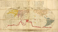
[Edo 1840, Suhraya]. Yellow blind-stamped paper covers,title slip, folds down to 16 x 28.7 cm., opens to 130.5 x 86 cm., covers bright, edges & corners a bit rubbed, hand-colored, a better than average example, reprint of Anei 11 [1828]. RARE . *** **** *** . . KAISEI NIHON YOCHI ROTEI ZENZU: COMPLETE MAP OF JAPAN . . . WITH DISTANCE CHART, LARGE WALL MAP . . . ORIGINAL WOODBLOCK PRINTED BLACK OUTLINE . . . SHOWING ALL OF JAPAN & OUTER ISLANDS IN 1779 . . WITH HAND-COLORING . . . JAPAN'S FIRST MAP SHOWING LATITUDE & LONGITUDE LINES . . . AN IMPORTANT & HISTORICAL 'FIRST' MAP , * This superb map was 'revised' by Japan's most eminent cartographer, NAGAKUBO Sekisui [1717-1801]. . This was the work of a Confucian scholar from Mito, and his maps were considered more accurate than his predecessors. He was the founder of Japanese cartography. . He first experienced seeing western maps while in Nagasaki, where he was a Rangakusha [student of Dutch learning]. He began to remake Japanese maps in western style. His first effort was: KAISEI NIHON YOCHI ROTEI ZENZU [COMPLETE MAP OF JAPAN] in 1779. This item we list is an early reprint of that map with his improvements. . This is the first Japanese map to show & use longitude & latitude lines. It describes map usage, with guide & itinerary, amount of walking days with distance chart from each city to next cities. Key & guide to symbols used on the map. A comprehensive map of all of Japan and her islands. . *** MAP CONTENTS & KEYS: The key shows color symbols for rivers mountains, castles, cities & villages, names of ports, famous places, Kuni names, Buddhist & Shinto [Jinja] shrines & temples, capitals, shipping lanes & distances, famous roads & Seki [road barriers], With four inset boxes of texts, description and colophon. . *** AUCTION RECORD: This map was sold by Christie's London July 12, 2008 for 3,600 GPB. Bunka 5th year [1809] a later edition mounted on a screen. See Christies lot lot-4750697. . *** GENERAL: Generic: This map is hand-colored over black-line key woodblocks. It has 10 color directional symbols. The front cover has the original title slip. . *** INDIVIDUAL COPY VARIANTS & DETAILS: . All copies are hand-colored gouache. . COPY 1: This the Bunka 8 year [1811] reprint of the Anei 8 year [1779] First Edition. With typical dusty & spotted, blind-stamped floral decorated covers, some old small spots, lower left front cover paste-on paper cites edition & bibliographic details brushed on paper, former owner's name Sumi ink brushed on back cover. . Contents clean, nicely hand-colored, some four-way folds reinforced in the distant past. The map is now firm and solid. All in all a better than average example. * COPY 2: This is the Tenpo 11 year [1840] reprint of the Anei 8th year [1779] edition. . The covers are very bright, clean and solid, an example. With excellent hand-coloring, with a couple of minor back side mends to hinge, now firm & solid. Far and above average example. * COPY 5: This is an excellent example, published in Koka 3rd year [1846]. An exact reprint of the FIRST EDITION, Anei 8 year [1779]. . Strong folds, no mends or reinforcements, beautifully hand-tinted, pastel colors. A far and above average example, seldom found in such excellent condition. . This map is contained in a new, 3-fold Chitsu, covered in indigo-blue cloth. . * COPY 6: Covers are in blue Swistika blind-stamped paper covered boards. The usual cover minor scuffing, edge & corner wear, several hinges reinforced from the back, now firm, stable & solid. Koka 3rd year, [1846]. . *** Color photos are posted to our website. . *** REFERENCES: . BEANS, George H.: A LIST OF JAPANESE MAPS OF THE TOKUGAWA ERA: 1791.1,1811.2, p.33 List. * Kazukata Unno: "Cartography in Japan" in History of Cartography vol. 2 book 2 (1994). * NANBA, Matsutaro. ed. et al.: OLD MAPS IN JAPAN, p.41 * Hugh Cortazzio Isles of Gold, Antique Maps of Japan, plate 4, for the 1811 issue. * See: nagakubosekisui.org: A website devoted to all things Sekisui. click at bottom for English. . THE MEMORIAL SOCIETY OF NAGAKUBO SEKISUI. Excellent website with details on his life & maps, accomplishments, personality, his work as a cartographer, geographer, Confucian & agricultural policy scholar. * JONES, Yolande. et al.: CHINESE AND JAPANESE MAPS: An Exhibition Organised By The British Museum, 1 February-31 December 1974. This map is listed as J22, 1779 edition. . * .
-
Bookseller
Independent bookstores
 (US)
(US)
- Book Condition Used -
- Binding Hardcover
- Keywords E-hon: Japanese Color Or B.w. Woodblock Illustrated & Printed Books; Maps Of Japan: Japanese/european Printed Maps & Cartography; Japanese Imprints: Any Item Printed In Japan; Guidebooks On Japan: Old, Rare, Scarce & Choice Items;
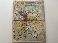
Japanese Colour Woodblock Historical Atlas of China. (Todo rekidai shugun enkaku chizu).
by China - Nagakubo, Sekisui
- Used
- Condition
- Used
- Quantity Available
- 1
- Seller
-
Vienna, Austria
- Item Price
-
CA$2,251.65
Show Details
Item Price
CA$2,251.65
![Chikyu Bankoku Sankai [Japanese World Map]](https://d3525k1ryd2155.cloudfront.net/h/529/440/1358440529.0.m.jpg)
Chikyu Bankoku Sankai
[Japanese World Map]
by Nagakubo Sekisui
- Used
- Condition
- Used - Very Good. Laid down on old silk. A few areas of wormholes repaired.
- Quantity Available
- 1
- Seller
-
Toronto, Ontario, Canada
- Item Price
-
CA$3,480.00
Show Details
Description:
Osaka, 1850. Very Good. Laid down on old silk. A few areas of wormholes repaired. . Notes: This world map shows Japan as the center of the earth, definitely a product of the isolationism that was the cornerstone of Japanese foreign policy under the Tokugawa shogunate from 1641 to 1853. Text is in Japanese. Reduced version of the famous map "Kaisei chikyu bankoku zenzu" by Sekisui Nagakubo (1717-1801) published ca. 1785, still based on the one by Matteo Ricci. Includes texts on the earth and climate zones, etc. According to Yamashita (page 19), these oval world maps, also known as "southern barbarian world maps", seemed at the time being rather outdated, but their representation was very popularNagakubo Sekisui (1717-1801) was an Edo period geographer and Confucian scholar, described by Yanagita Kunio as the founder of Japanese geography. Sekisui is credited with the creation of numerous maps and travel writings, and innovations such as the first Japanese map to employ lines of latitude and…
Read More Item Price
CA$3,480.00

More Photos
Todo rekidai shugun enkakuzu ("Maps Showing the Historical Development of China").
by NAGAKUBO, Sekisui
- Used
- Hardcover
- Condition
- Used
- Binding
- Hardcover
- Quantity Available
- 1
- Seller
-
London, United Kingdom
- Item Price
-
CA$3,554.20
Show Details
Description:
Osaka: Naniwa shorin,, 1835. With 13 vibrant historical maps A colourful late-Edo edition of this historical atlas by the founder of modern Japanese cartography. The detailed maps trace China's geopolitical and territorial evolution from the time of the legendary emperor Yu the Great through to the Qing dynasty. A final map shows East Asia, the Pacific, and the western fringes of North America. The maps were prepared by Nagakubo Sekisui (1717-1801), who pioneered the accurate representation of the world on paper. In 1774, he published one of the first Japanese maps to include latitude and longitude. These scientific elements are also found on several of the maps in this publication, along with roads, rivers, mountains, and other cartographical features. During periods of relative unity, such as the early Han dynasty or the Qing, the area of China is uncoloured, offering a marked contrast to times of intra-continental conflict and federation. Nagakubo's productions were for the discerning,…
Read More Item Price
CA$3,554.20

[From Preface]: Tōō kikō 東奧紀行 [Travelogue from Mutsu & Dewa Provinces]
by NAGAKUBO, Sekisui 長久保赤水
- Used
- Condition
- Used
- Quantity Available
- 1
- Seller
-
New York, New York, United States
- Item Price
-
CA$5,220.00
Show Details
Description:
19 woodcut illus. & maps, some double-page. 33 folding leaves. Large 8vo, orig. wrappers with the orig. title-slip (label rubbed), new stitching. Osaka: Asano yahei 浅野彌兵衛, 1792. First edition of this travelogue from a journey to the northern part of the main island of Honshu. Mutsu and Dewa provinces were very large territories that today correspond to Fukushima, Miyagi, Iwate, Aomori, Yamagata, and Akita prefectures. At the time of publication, the region was relatively far removed from the center of Japanese civilization. Locations pictured in the book include Shiogama, a town in present-day Miyagi Prefecture; the group of pine-covered islands called Matsushima; and Mount Chōkai, an active volcano in the region; and other places. Nagakubo (1717-1801) was "a geographer and mapmaker, one of the first to place Japan on the longitude and latitude grid, and creator of a number of influential woodblock-print maps of Japan and of Asia. Sekisui also worked on the Dai Nihon shi, the grand…
Read More Item Price
CA$5,220.00
More Photos
Kaisei Chikyu Bankoku Zenzu 改正地球万国全図 (= Geographic complete map enhanced with all the countries of the world).
by [MAP OF THE WORLD]. NAGAKUBO SEKISUI
- Used
- first
- Condition
- Used
- Quantity Available
- 1
- Seller
-
Paris, France
- Item Price
-
CA$55,540.70
Show Details
Description:
Yamazaki Kinbe, Edo et Asana Yahei, Osaka, 5th year of the Tenmei period (1785).Large wood-engraved map of 165 x 91 cm (65 x 35,8 inches), entirely hand-colored at the time. Red ink stamp in the bottom. Folded and preserved in a modern blue cloth protection case. Very good condition.
First edition of this superb and rare map of the World published in Japan in 1785, showing the progress of the Japanese geographical and cartographical knowledge at the end of the 18th century.
Nagakubo Sekisui 長久保赤水 (1717-1801) is the most famous Japanese cartographer of the end of the 18th century.
This map presents a lot of information: at the top right, a cartouche encloses a text in classical Chinese by Katsuragawa Hoshu
(1751-1809), famous doctor at the Shogun court, knowing Dutch and passionate about sciences and European cartography.
At the top left, another cartouche presents 70 lines of text in Japanese written by the author of the map, with explanations as for the contribution of Dutch science to the… Read More
Item Price
CA$55,540.70