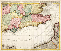
LA PLUS GRANDE PARTIE de la MANCHE, qui contient LES CÔTES DE ANGLETERE.: (Situées au SUD-EST, ou est LA TAMISE &c.) et celles de FRANCE, OU LA partie septentrionale du GOUV. DE NORMANDIE, les BORDS MARTIMES de PICARDIE &c.
by OTTENS, Reiner & Joshua
- Used
- Condition
- See description
- Seller
-
London, United Kingdom
Payment Methods Accepted
About This Item
Amsterdam., c1740. A fine engraved map of English Channel with the Strait of Dover - Calais. The map is showing the south east corner of England as far north as Colchester and as far west as Lulworth in Dorset and Gloucester. Part of the continental coast is shown with the island of Alderney. The title, scales and explanation appear across the top of the map. Copper engraving. Original colour. Fine condition Size: 59 x 49 cm.
Reviews
(Log in or Create an Account first!)
Details
- Bookseller
- Peter Harrington
 (GB)
(GB)
- Bookseller's Inventory #
- 55970
- Title
- LA PLUS GRANDE PARTIE de la MANCHE, qui contient LES CÔTES DE ANGLETERE.
- Author
- OTTENS, Reiner & Joshua
- Book Condition
- Used
- Place of Publication
- Amsterdam.
- Date Published
- c1740
Terms of Sale
Peter Harrington
All major credit cards are accepted. Both UK pounds and US dollars (exchange rate to be agreed) accepted. Books may be returned within 14 days of receipt for any reason, please notify first of returned goods.
About the Seller
Peter Harrington
Biblio member since 2006
London
About Peter Harrington
Since its establishment, Peter Harrington has specialised in sourcing, selling and buying the finest quality original first editions, signed, rare and antiquarian books, fine bindings and library sets. Peter Harrington first began selling rare books from the Chelsea Antiques Market on London's King's Road. For the past twenty years the business has been run by Pom Harrington, Peter's son.
Glossary
Some terminology that may be used in this description includes:
- Fine
- A book in fine condition exhibits no flaws. A fine condition book closely approaches As New condition, but may lack the...

Vertigo Comics
Vertigo Comics, an imprint of DC Comics, is being retired in 2020 after a 27 year run of groundbreaking comics. The imprint was DC’s home for mature tales that were often horror-themed or otherwise dark in nature. Learn more about Vertigo, home of V for Vendetta, Sandman, and Fables.

Collecting One Book
Instead of collecting by series, author, publisher...why not just one title? Learn more about collecting variations and editions of one book.
