Description:
1802. Copper-line engraving. 250mm by 190mm (window). Plan & Elevation of a Church. Built at Parramatta New South Wales during the Government of John Hunter Esq 1800.' From 'An account of the English colony in New South Wales' by David Collins, published by Cadell & Davies. St John's, Parramatta was the only church in the colony until 1809. Small sort break in paper on far right side.Acid free mount.
Germania Antiqua by Neele, Samuel John - 1783
by Neele, Samuel John

Germania Antiqua
by Neele, Samuel John
- Used
London: Thomas Stackhouse, 1783. Other. 357 by 362mm (14 by 14¼ inches).. Original antike Kupferstichkarte in Grenz- und Flächenkolorit. Das Kartenbild reicht von der Nord- und Ostsee bis hin zum nördlichsten Teil der Adria. Im linken unteren Bildbereich ist der Titel eingraviert. In ausgezeichnetem Zustand. Leichte Bräunungen im Papier.
-
Bookseller
Antiquariat Reinhold Berg ek
 (DE)
(DE)
- Format/Binding Other
- Book Condition Used
- Quantity Available 1
- Publisher Thomas Stackhouse
- Place of Publication London
- Date Published 1783
- Keywords Antique map Map:Europe:Germany Germany Neele, Samuel John Germania Antiqua London Thomas Stackhouse 1783
- Product_type map
- Size 357 by 362mm (14 by 14¼ inches).

Plan & Elevation of a Church. Built at Parramatta New South Wales
by Samuel John Neele (engraver)
- Used
- Condition
- Used
- Quantity Available
- 1
- Seller
-
DONCASTER EAST, Victoria, Australia
- Item Price
-
CA$164.72
Show Details
Item Price
CA$164.72

An Interesting Letter to a Mr Dodds from the Engraver Samuel John Neele With Regards to Copper Plates for Probably a Book on The Battle of Waterloo.
by Samuel John Neele SIGNED
- Used
- good
- Signed
- first
- Condition
- Used - Good
- Edition
- First Edition
- Quantity Available
- 1
- Seller
-
Northampton, Northamptonshire, United Kingdom
- Item Price
-
CA$173.55
Show Details
Description:
UK, 1816. First Edition . Paper. Good. 48mo - over 3 - 4" tall. An Interesting Letter to a Mr Dodds from the Engraver Samuel John Neele With Regards to Copper Plates for Probably a Book on The Battle of Waterloo. Dated 1816. Samuel John Neele (1758-1824) was an important British engraver and cartographer who is known to have produced a substantial body of work including both maps and portraits. He operated a print shop in London with his sons between 1782 and 1833.. From a autograph book kept by A. P. Watt (1834-1914), founder of A. P. Watt & Son in 1875, the world's first literary agents. Size is 170m x 105mm. Condition is good. Light folding creases. More images can be taken upon request. Ref18423
Item Price
CA$173.55

Present Spain and Portugal
by NEELE, Samuel John
- Used
- very good
- Condition
- Used - very good
- Quantity Available
- 1
- Seller
-
New York, New York, United States
- Item Price
-
CA$207.82
Show Details
Description:
London: T. Stackhouse, 1785. unbound. very good. Map. Engraving with hand color. Image measures 14.5" x 15.5".<br/><br/> Nice map of the Iberian Peninsula. Left and right margins are cropped, very small tears to bottom edge and small chip to lower right corner.<br/><br/>
Item Price
CA$207.82
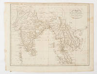
Map of the East Indies from the Best Authorities.
by [SOUTH ASIA - MAP]. NEELE, SAMUEL JOHN
- Used
- Condition
- Used
- Quantity Available
- 1
- Seller
-
Canberra, Australian Capital Territory, Australia
- Item Price
-
CA$205.90
Show Details
Description:
London & Glasgow.: (W. and D. Brownlie). [1805].. Engraved map, 18.7 x 23.9 cm, original folds, age toned and spotted, inner margin a trifle ragged, paper thinning in a few spots, in good condition. Attractive map engraved for "A System of Geography; or A Descriptive, Historical, and Philosophical View of the Several Quarters of the World" published in 1805. .
Item Price
CA$205.90
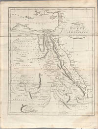
Map of Egypt, and Abyssinia, from the best Authorities.
by [EGYPT - MAP] NEELE, SAMUEL JOHN-ENGRAVER
- Used
- Condition
- Used
- Quantity Available
- 1
- Seller
-
Canberra, Australian Capital Territory, Australia
- Item Price
-
CA$228.78
Show Details
Description:
(London).. circa1803.. Engraved map, 23 x 18.5 cm, original folds, small split to one fold affecting the margin only, paper age- toned, lower corner darkened, and, on the verso inked circles to the lower half in an early hand, but in good condition. Finely engraved early 19th Century map also showing, to the north, Syria, Palestine and Cyprus and Darfur and Mountains of the Moon, Sources of the Nile to the South. .
Item Price
CA$228.78

Autograph Note in the third person, “S.Neele presents his respects ...”, to Messrs. Cadell & Davies, sending [not present] “his two years General Account in which no plate is charged that has not actually been delivered” and listing the maps still in preparation
by NEELE, Samuel John
- Used
- Condition
- Used
- Quantity Available
- 1
- Seller
-
London, United Kingdom
- Item Price
-
CA$347.10
Show Details
Description:
Strand, 7 March 1810. 4 x 6 inches, generally in good condition. Rare. Samuel John Neele (1758-1824), engraver, illustrator and mapmaker. The Neele family were prolific engravers who produced maps for many atlases and topographical works, including town plans. “... the following are in hand, & in a considerable state of forwardness: Spain & Portugal, Northn. U:States (these two will be finished in a few weeks, & with Southern Africa might form No. 4); The Caraccas; Germany, N. of the Marn; Austrian Territories; North Italy. &c &c.”
Item Price
CA$347.10

Map of the County of Middlesex.
by Neele, Samuel John
- Used
- very good
- Condition
- Used - Very Good
- Quantity Available
- 1
- Seller
-
Toronto, Ontario, Canada
- Item Price
-
CA$381.01
Show Details
Description:
London, c.1811. Very Good. Size : 178x238 (mm), 7.01x9.37 (Inches), Coloring: Hand Colored, Category: Maps Europe United Kingdom England Counties;
Item Price
CA$381.01

A Map of those Parishes in the Counties of Kent and Essex which lie within Twelve Miles of London.
by Neele, Samuel John
- Used
- very good
- Condition
- Used - Very Good
- Quantity Available
- 1
- Seller
-
Toronto, Ontario, Canada
- Item Price
-
CA$381.01
Show Details
Description:
London, c.1811. Very Good. Size : 233x177 (mm), 9.17x6.97 (Inches), Coloring: Hand Colored, Category: Maps Europe United Kingdom England Counties;
Item Price
CA$381.01
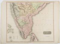
British India, Southern Part.
by [INDIA - MAP] NEELE, SAMUEL JOHN. (ENGRAVER)
- Used
- Condition
- Used
- Quantity Available
- 1
- Seller
-
Canberra, Australian Capital Territory, Australia
- Item Price
-
CA$388.92
Show Details
Description:
London.: Thomson.. 1816.. Engraved map with full handcolour, 50.5 x 59.7 cms ; 53.9 x 73.8 cms (sheet), central fold, a few minor edge tears one intruding into the top border (the map unscathed), marginal edgewear, two corners with some loss , but the map in very good crisp condition. An elegant map with great detail, prepared for John Thomson's influential "New General Atlas" (1814-1821). Showing India from 20 degrees to 7 degrees north of the equator and includes the northern half of Ceylon, with territorial interests attractively coloured. .
Item Price
CA$388.92

Plan of Hyde Park as it was in 1725.
by Neele, Samuel John
- Used
- very good
- Condition
- Used - Very Good
- Quantity Available
- 1
- Seller
-
Toronto, Ontario, Canada
- Item Price
-
CA$519.56
Show Details
Description:
London, c.1811. Very Good. Size : 217x181 (mm), 8.54x7.13 (Inches), Coloring: Hand Colored, Category: Maps Europe United Kingdom England London;
Item Price
CA$519.56
